ملف:High Street, Lydd - geograph.org.uk - 215215.jpg
لا توجد دقة أعلى متوفرة.
High_Street,_Lydd_-_geograph.org.uk_-_215215.jpg (640 × 474 بكسل حجم الملف: 116 كيلوبايت، نوع MIME: image/jpeg)
وصف قصير
| ⧼wm-license-information-description⧽ |
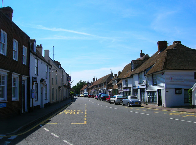
English: High Street, Lydd. The first record of a town being her is the 9th century when the Saxons called it Hlydda meaning shore. Built on a shingle bar and often isolated by marshes and water the town has a feel of a frontier town in the American west rather than genteel Kent. Naturally, the smuggling trade found a welcome home here from the 14th century onwards when the Owlers (name derived from their making noises like an owl at night to communicate with each other) smuggled wool to France. During the 18th and 19th century it was often said that the entire population was involved in one form or another often in league with the big gangs from the Wealden towns. The George Hotel to the left with the flagpoles attached was the scene of a big shoot out in 1747 when arrested smugglers detained by a small unit of soldiers were attacked by 500 armed thugs. This view was taken from the southern exit of the churchyard.
|
| ⧼wm-license-information-date⧽ | 2006 |
| ⧼wm-license-information-source⧽ | From geograph.org.uk |
| ⧼wm-license-information-author⧽ | Simon Carey |
| ⧼wm-license-cc-attribution⧽ (قالب:I18n/Credit line) |
Simon Carey / High Street, Lydd / |
50°57′06″N 0°54′18″E / 50.9518°N 0.905°E قالب:Object location
_heading:225)
ترخيص
تاريخ الملف
اضغط على زمن/تاريخ لرؤية الملف كما بدا في هذا الزمن.
| زمن/تاريخ | صورة مصغرة | الأبعاد | مستخدم | تعليق | |
|---|---|---|---|---|---|
| حالي | ★ مراجعة معتمدة 21:19، 10 أكتوبر 2023 | | 640 × 474 (116 كيلوبايت) | Pastakhov (نقاش | مساهمات) | Upload https://upload.wikimedia.org/wikipedia/commons/a/ad/High_Street%2C_Lydd_-_geograph.org.uk_-_215215.jpg |
لا يمكنك استبدال هذا الملف.
وصلات
لا يوجد صفحات تصل لهذه الصورة.