ملف:Guadalupe location.png
لا توجد دقة أعلى متوفرة.
Guadalupe_location.png (770 × 470 بكسل حجم الملف: 58 كيلوبايت، نوع MIME: image/png)
وصف قصير
| ⧼wm-license-information-description⧽ |
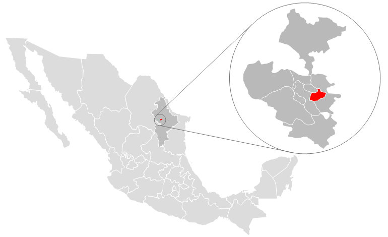
Map of location of Guadalupe, Mexico (red) within the country and state of Nuevo León. Dark gray surrounding the city shows the Monterrey metropolitan area. Map designed by Alex Covarrubias. |
| ⧼wm-license-information-date⧽ | قالب:Original upload date |
| ⧼wm-license-information-source⧽ | No machine-readable source provided. Own work assumed (based on copyright claims). |
| ⧼wm-license-information-author⧽ | No machine-readable author provided. AlexCovarrubias assumed (based on copyright claims). |
ترخيص
تاريخ الملف
اضغط على زمن/تاريخ لرؤية الملف كما بدا في هذا الزمن.
| زمن/تاريخ | صورة مصغرة | الأبعاد | مستخدم | تعليق | |
|---|---|---|---|---|---|
| حالي | ★ مراجعة معتمدة 04:47، 25 أكتوبر 2023 | | 770 × 470 (58 كيلوبايت) | Pastakhov (نقاش | مساهمات) | Upload https://upload.wikimedia.org/wikipedia/commons/7/7c/Guadalupe_location.png |
لا يمكنك استبدال هذا الملف.
وصلات
لا يوجد صفحات تصل لهذه الصورة.