ملف:Great Lakes bathymetry map.png
الملف الأصلي (1٬024 × 731 بكسل حجم الملف: 1٫34 ميجابايت، نوع MIME: image/png)
وصف قصير
| ⧼wm-license-information-description⧽ |
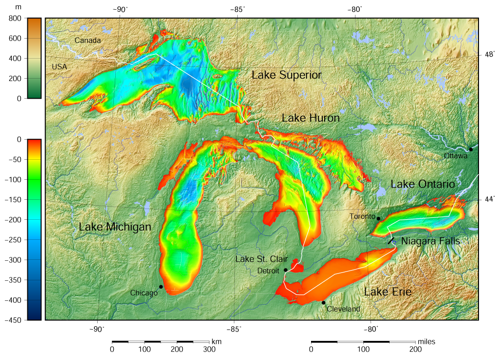
English: Great Lakes bathymetry and surrounding area shaded relief map. Lakes are contoured with interval 100 m.
Lake Superior is incomplete. |
| ⧼wm-license-information-date⧽ | 2015 |
| ⧼wm-license-information-source⧽ | قالب:Own using the following Public Domain datasets (grids):
The color palette of the depth scale was made to be more or less similar to the color palettes used on the NGDC Great Lakes maps. قالب:Created with GMT |
| ⧼wm-license-information-author⧽ | Darekk2 using the Great Lakes Bathymetry and GLOBE tiles |
| ⧼wm-license-information-other-versions⧽ |
The same map but not shaded: Great Lakes bathymetry map 2.png |

ترخيص
Attribution (in addition to the author of this map):
The NGDC in it's copyright notice says:
As required by 17 U.S.C. 403, third parties producing copyrighted works consisting predominantly of the material produced by U.S. government agencies must provide notice with such work(s) identifying the U.S. Government material incorporated and stating that such material is not subject to copyright protection within the United States. (...)
(for credits see the Source section).
|
|
هذا العمل مرخّص تحت رخصة المشاع الإبداعي الملزمة بنسبة العمل لمؤلفه وبترخيص الأعمال المشتقة بالمثل 4.0. |
تاريخ الملف
اضغط على زمن/تاريخ لرؤية الملف كما بدا في هذا الزمن.
| زمن/تاريخ | صورة مصغرة | الأبعاد | مستخدم | تعليق | |
|---|---|---|---|---|---|
| حالي | ★ مراجعة معتمدة 10:32، 13 نوفمبر 2023 | | 1٬024 × 731 (1٫34 ميجابايت) | Pastakhov (نقاش | مساهمات) | Upload https://upload.wikimedia.org/wikipedia/commons/3/38/Great_Lakes_bathymetry_map.png |
لا يمكنك استبدال هذا الملف.
وصلات
الصفحات التالية تحتوي على وصلة لهذه الصورة: