ملف:Grandduchy Frankfurt 1812.png

حجم هذه المعاينة: 759 × 599 بكسل. البعد الآخر: 2٬244 × 1٬772 بكسل.
الملف الأصلي (2٬244 × 1٬772 بكسل حجم الملف: 1٫02 ميجابايت، نوع MIME: image/png)
| ⧼wm-license-information-description⧽ |
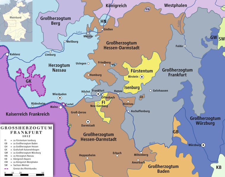
English: Map of the Grand Duchy of Frankfurt, 1812
Deutsch: Karte des Großherzogtums Frankfurt, 1812
|
|||||
| ⧼wm-license-information-date⧽ | 2011 | |||||
| ⧼wm-license-information-source⧽ | own drawing/Source of Information: Putzger – Historischer Weltatlas, 89. Auflage, 1965; Westermanns Großer Atlas zur Weltgeschichte, 1969; Haacks geographischer Atlas. VEB Hermann Haack Geographisch-Kartographische Anstalt, Gotha/Leipzig, 1. Auflage, 1979. | |||||
| ⧼wm-license-information-author⧽ | Ziegelbrenner | |||||
| ⧼wm-license-information-permission⧽ (⧼wm-license-information-permission-reusing-text⧽) |
|
|||||
| ⧼wm-license-information-other-versions⧽ |

تاريخ الملف
اضغط على زمن/تاريخ لرؤية الملف كما بدا في هذا الزمن.
| زمن/تاريخ | صورة مصغرة | الأبعاد | مستخدم | تعليق | |
|---|---|---|---|---|---|
| حالي | ★ مراجعة معتمدة 05:59، 11 أكتوبر 2023 | | 2٬244 × 1٬772 (1٫02 ميجابايت) | Pastakhov (نقاش | مساهمات) | Upload https://upload.wikimedia.org/wikipedia/commons/b/be/Grandduchy_Frankfurt_1812.png |
لا يمكنك استبدال هذا الملف.
وصلات
لا يوجد صفحات تصل لهذه الصورة.