ملف:GeoServer GeoNetwork with web app.svg

حجم معاينة PNG لذلك الملف ذي الامتداد SVG: 685 × 600 بكسل. البعد الآخر: 2٬339 × 2٬048 بكسل.
الملف الأصلي (ملف SVG، أبعاده 813 × 712 بكسل، حجم الملف: 103 كيلوبايت)
| ⧼wm-license-information-description⧽ |
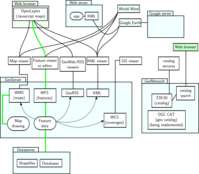
GeoServer and GeoNetwork with interfaces and applications sketch. Green represents read and write paths. Dotted arrowed line indicates mostly read-only data flow. |
| ⧼wm-license-information-date⧽ | 2010-04-30 06:38 (UTC) |
| ⧼wm-license-information-source⧽ | |
| ⧼wm-license-information-author⧽ |
|
| [This is a retouched picture, which means that it has been digitally altered from its original version. Modifications: Made a vector version. The original can be viewed here: GeoServer_GeoNetwork_with_web_app.png. Modifications made by Belamp.] Error: {{Lang}}: text has italic markup (help)
|
|

قالب:Original upload log
This image is a derivative work of the following images:
- File:GeoServer_GeoNetwork_with_web_app.png licensed with Cc-by-sa-3.0,2.5,2.0,1.0, GFDL
- 2007-12-07T23:39:23Z SEWilco 698x569 (49691 Bytes) == Summary == {{Information |Description=GeoServer and GeoNetwork with interfaces and applications sketch. Green represents read and write paths. Dotted arrowed line indicates mostly read-only data flow. |Source=self-made |
تاريخ الملف
اضغط على زمن/تاريخ لرؤية الملف كما بدا في هذا الزمن.
| زمن/تاريخ | صورة مصغرة | الأبعاد | مستخدم | تعليق | |
|---|---|---|---|---|---|
| حالي | ★ مراجعة معتمدة 16:07، 7 ديسمبر 2023 | | 813 × 712 (103 كيلوبايت) | Pastakhov (نقاش | مساهمات) | Upload https://upload.wikimedia.org/wikipedia/commons/0/09/GeoServer_GeoNetwork_with_web_app.svg |
لا يمكنك استبدال هذا الملف.
وصلات
لا يوجد صفحات تصل لهذه الصورة.