ملف:Gaelic Games County Map.svg

حجم معاينة PNG لذلك الملف ذي الامتداد SVG: 424 × 600 بكسل. البعد الآخر: 1٬448 × 2٬048 بكسل.
الملف الأصلي (ملف SVG، أبعاده 744 × 1٬052 بكسل، حجم الملف: 1٫08 ميجابايت)
| ⧼wm-license-information-description⧽ |
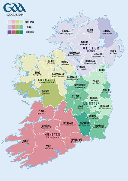
Counties contesting the All-Ireland Senior Football Championship (yellow), All-Ireland Senior Hurling Championship (blue), or both (green) |
| ⧼wm-license-information-date⧽ | 2010-07-20 17:58 (UTC) |
| ⧼wm-license-information-source⧽ | |
| ⧼wm-license-information-author⧽ |
|
| [This is a retouched picture, which means that it has been digitally altered from its original version. Modifications: Altered colours of counties and legend. The original can be viewed here: Population_density_of_Ireland_map2002.svg. Modifications made by Teester.] Error: {{Lang}}: text has italic markup (help)
|
قالب:Original upload log
This image is a derivative work of the following images:
- File:Population_density_of_Ireland_map2002.svg licensed with PD-self
- 2009-10-17T14:30:14Z The Illusional Ministry 800x1000 (635831 Bytes) Dublin now in black text
- 2009-10-17T14:27:13Z The Illusional Ministry 800x1000 (636262 Bytes) {{Information |Description=Map of Ireland's population density (people per km2). Based upon Republic of Ireland - 2002 Census results. |Source=*[[:File:Ireland_complete.svg|]] |Date=2009-10-17 14:25 (UTC) |Author=*[[:File:Ire
تاريخ الملف
اضغط على زمن/تاريخ لرؤية الملف كما بدا في هذا الزمن.
| زمن/تاريخ | صورة مصغرة | الأبعاد | مستخدم | تعليق | |
|---|---|---|---|---|---|
| حالي | ★ مراجعة معتمدة 07:38، 14 نوفمبر 2023 | | 744 × 1٬052 (1٫08 ميجابايت) | Pastakhov (نقاش | مساهمات) | Upload https://upload.wikimedia.org/wikipedia/commons/7/72/Gaelic_Games_County_Map.svg |
لا يمكنك استبدال هذا الملف.
وصلات
لا يوجد صفحات تصل لهذه الصورة.