ملف:Flysch coast between Deba and Zumaia.jpg

حجم هذه المعاينة: 800 × 420 بكسل. البعدان الآخران: 2٬560 × 1٬345 بكسل | 8٬563 × 4٬500 بكسل.
الملف الأصلي (8٬563 × 4٬500 بكسل حجم الملف: 14٫71 ميجابايت، نوع MIME: image/jpeg)
وصف قصير
| ⧼wm-license-information-description⧽ |
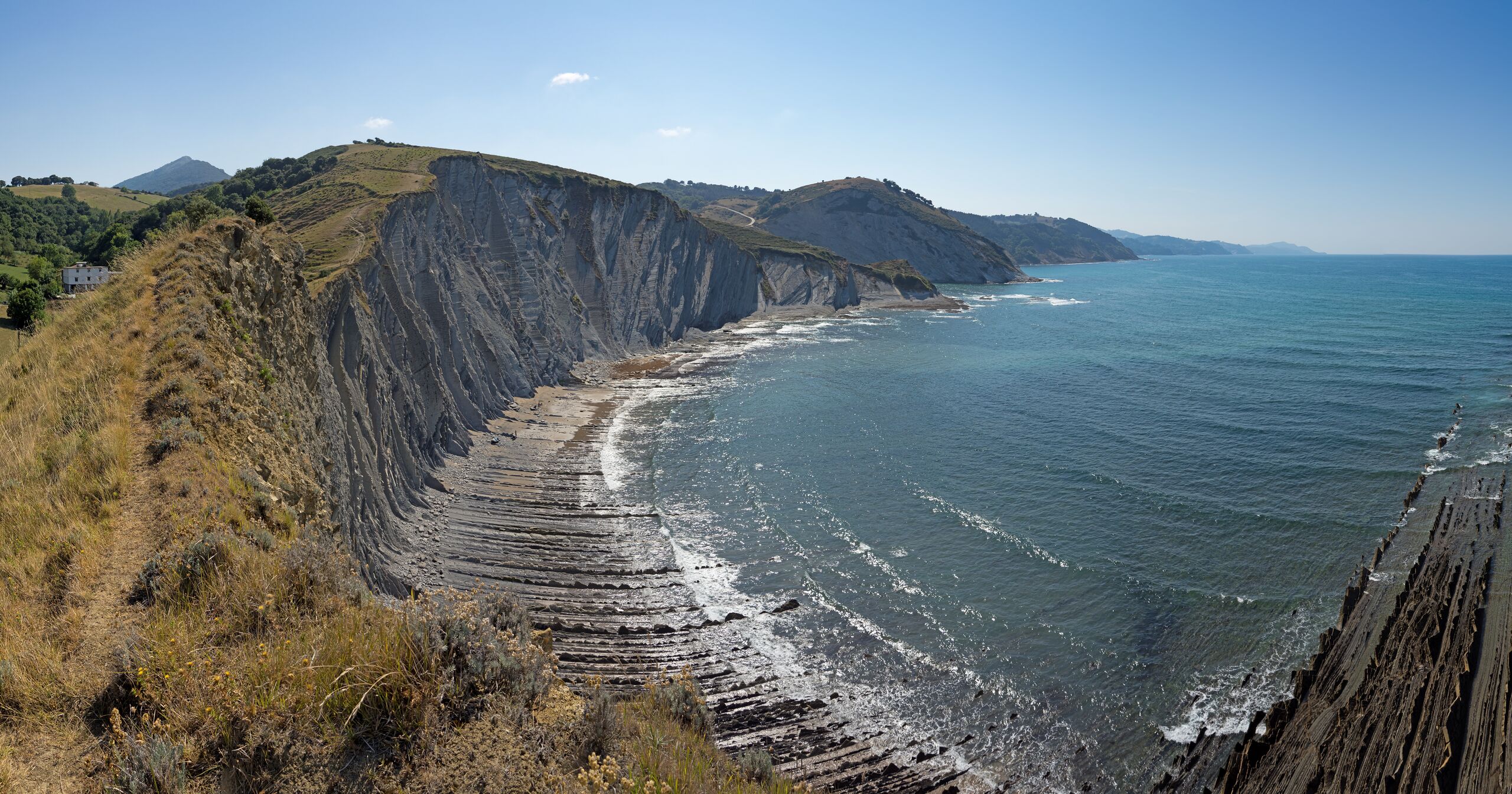
Deutsch: Flyschküste im Geopark Baskische Küste zwischen Deba und Zumaia
English: Cliffs of flysch in the Basque Coast Geopark
Español: Acantilados en los que afloran rocas sedimentarias en facies de tipo flysch en Geoparque de la Costa Vasca e en biotopo protegido del tramo litoral Deba-Zumaia
Euskara: Euskal Kostaldeko Geoparkea eta arteko itsasertzeko babestutako biotopoa flysch motako fazieetan arroka sedimentarioak azaleratzen diren itsaslabarrak. قالب:Wiki Loves Earth 2023 special nomination
|
| ⧼wm-license-information-date⧽ | 2022, {{time}} – invalid date format 50 (help) |
| ⧼wm-license-information-source⧽ | ⧼Wm-license-own-work⧽ |
| ⧼wm-license-information-author⧽ | Jörg Braukmann |
43°17′54″N 2°18′38″W / 43.298211°N 2.310466°W قالب:Wiki Loves Earth 2023
قالب:Assessment
|
ترخيص
|
تاريخ الملف
اضغط على زمن/تاريخ لرؤية الملف كما بدا في هذا الزمن.
| زمن/تاريخ | صورة مصغرة | الأبعاد | مستخدم | تعليق | |
|---|---|---|---|---|---|
| حالي | ★ مراجعة معتمدة 04:09، 9 نوفمبر 2023 | | 8٬563 × 4٬500 (14٫71 ميجابايت) | Pastakhov (نقاش | مساهمات) | Upload https://upload.wikimedia.org/wikipedia/commons/4/4f/Flysch_coast_between_Deba_and_Zumaia.jpg |
لا يمكنك استبدال هذا الملف.
وصلات
لا يوجد صفحات تصل لهذه الصورة.
معلومات الصورة (ميتا)
تصنيفات:
- Assessment tagged pages that are not in the file namespace
- Broken FPC links
- Self-published work
- Basque Coast Geopark-Flysch
- Uploaded via Campaign:wle-es
- Sakoneta (Deba)
- Breaking ocean waves in Spain
- Summer in Spain
- August 2022 Spain photographs
- Photographs taken on 2022-08-08
- Featured pictures of the Basque Autonomous Community
- Quality images of the Basque Autonomous Community
- Featured pictures from Wiki Loves Earth 2023 in Spain
- Quality images from Wiki Loves Earth 2023 in Spain
- All media supported by Wikimedia España in 2023