ملف:FirthofLornmap.png
لا توجد دقة أعلى متوفرة.
FirthofLornmap.png (538 × 573 بكسل حجم الملف: 17 كيلوبايت، نوع MIME: image/png)

|
[All images in this gallery should be recreated using vector graphics as an SVG file. This has several advantages; see Commons:Media for cleanup for more information. If an SVG form of this image is already available, please upload it. After uploading an SVG, replace this template with {{vector version available|new image name.svg}}.] Error: {{Lang}}: text has italic markup (help) |
|
العربية | български | català | čeština | dansk | Deutsch | English | Esperanto | español | français | galego | 한국어 | italiano | magyar | lietuvių | 日本語 | Plattdüütsch | Nederlands | norsk | polski | português | română | русский | suomi | svenska | Türkçe | українська | 中文(繁體) | 中文(简体) | +/− | |
| ⧼wm-license-information-description⧽ |
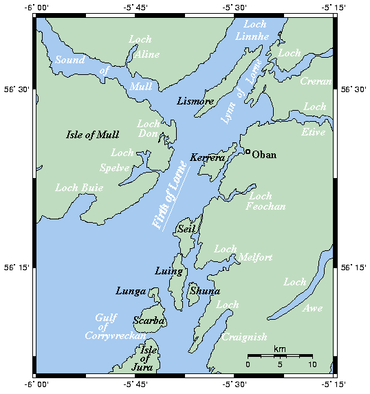
English: Map of the Firth of Lorn(e) and nearby waterways on Scotland's west coast.
This map's source is here, with the uploader's modifications, and the GMT homepage says that the tools are released under the GNU General Public License.
|
| ⧼wm-license-information-date⧽ | قالب:Original upload date |
| ⧼wm-license-information-source⧽ | قالب:Transferred from |
| ⧼wm-license-information-author⧽ | قالب:User at project |
ترخيص
قالب:GFDL-user-en-with-disclaimers
قالب:Original upload log
قالب:Original description page
- 2006-01-25 01:42 Kelisi 538×573× (17451 bytes) Map of the Firth of Lorn(e) and nearby waterways on Scotland's west coast. This map's source is [http://www.aquarius.geomar.de/omc/make_map.html here], with the uploader's modifications, and the [http://gmt.soest.hawaii.edu/ GMT homepage] says that the t
تاريخ الملف
اضغط على زمن/تاريخ لرؤية الملف كما بدا في هذا الزمن.
| زمن/تاريخ | صورة مصغرة | الأبعاد | مستخدم | تعليق | |
|---|---|---|---|---|---|
| حالي | ★ مراجعة معتمدة 13:15، 6 أكتوبر 2023 | | 538 × 573 (17 كيلوبايت) | Pastakhov (نقاش | مساهمات) | Upload https://upload.wikimedia.org/wikipedia/commons/8/86/FirthofLornmap.png |
لا يمكنك استبدال هذا الملف.
وصلات
لا يوجد صفحات تصل لهذه الصورة.