ملف:Farset river map.jpg
لا توجد دقة أعلى متوفرة.
Farset_river_map.jpg (451 × 450 بكسل حجم الملف: 94 كيلوبايت، نوع MIME: image/jpeg)
وصف قصير
| ⧼wm-license-information-description⧽ |
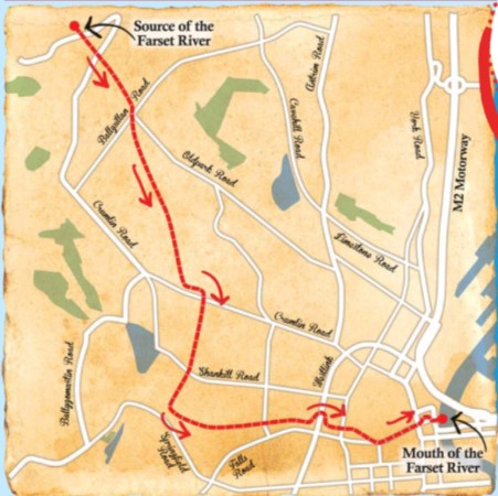
English: A map showing the course of the Farset river, from Ballysillan in North Belfast to it's outlet into the Lagan in the city centre.
|
| ⧼wm-license-information-date⧽ | 2020 |
| ⧼wm-license-information-source⧽ | ⧼Wm-license-own-work⧽ |
| ⧼wm-license-information-author⧽ | Citizen69 |
ترخيص
|
تاريخ الملف
اضغط على زمن/تاريخ لرؤية الملف كما بدا في هذا الزمن.
| زمن/تاريخ | صورة مصغرة | الأبعاد | مستخدم | تعليق | |
|---|---|---|---|---|---|
| حالي | ★ مراجعة معتمدة 13:28، 3 ديسمبر 2023 | | 451 × 450 (94 كيلوبايت) | Pastakhov (نقاش | مساهمات) | Upload https://upload.wikimedia.org/wikipedia/commons/4/4b/Farset_river_map.jpg |
لا يمكنك استبدال هذا الملف.
وصلات
لا يوجد صفحات تصل لهذه الصورة.