ملف:Falklandsmap san carlos landings ita.png
لا توجد دقة أعلى متوفرة.
Falklandsmap_san_carlos_landings_ita.png (346 × 372 بكسل حجم الملف: 19 كيلوبايت، نوع MIME: image/png)
وصف قصير
| ⧼wm-license-information-description⧽ |
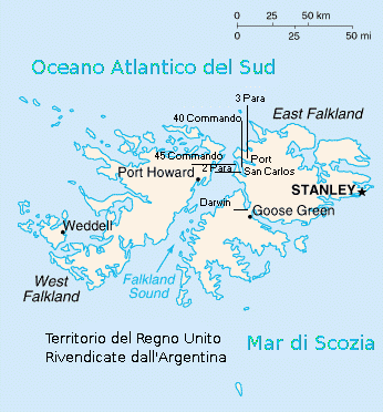
English: Map of Falkland Islands with important places and some italian translations Italiano: Mappa delle Isole Falkland con luoghi significativi e traduzione in italiano
|
| ⧼wm-license-information-date⧽ | 2005 |
| ⧼wm-license-information-source⧽ | World Factbook published by Central Intelligence Agency |
| ⧼wm-license-information-author⧽ | Central Intelligence Agency, Pigr8 for italian translation |
ترخيص
تاريخ الملف
اضغط على زمن/تاريخ لرؤية الملف كما بدا في هذا الزمن.
| زمن/تاريخ | صورة مصغرة | الأبعاد | مستخدم | تعليق | |
|---|---|---|---|---|---|
| حالي | ★ مراجعة معتمدة 02:18، 25 أكتوبر 2023 | | 346 × 372 (19 كيلوبايت) | Pastakhov (نقاش | مساهمات) | Upload https://upload.wikimedia.org/wikipedia/commons/6/69/Falklandsmap_san_carlos_landings_ita.png |
لا يمكنك استبدال هذا الملف.
وصلات
لا يوجد صفحات تصل لهذه الصورة.