ملف:Europäische Wasserscheiden.png

الملف الأصلي (1٬200 × 1٬184 بكسل حجم الملف: 526 كيلوبايت، نوع MIME: image/png)
وصف قصير
| ⧼wm-license-information-description⧽ |
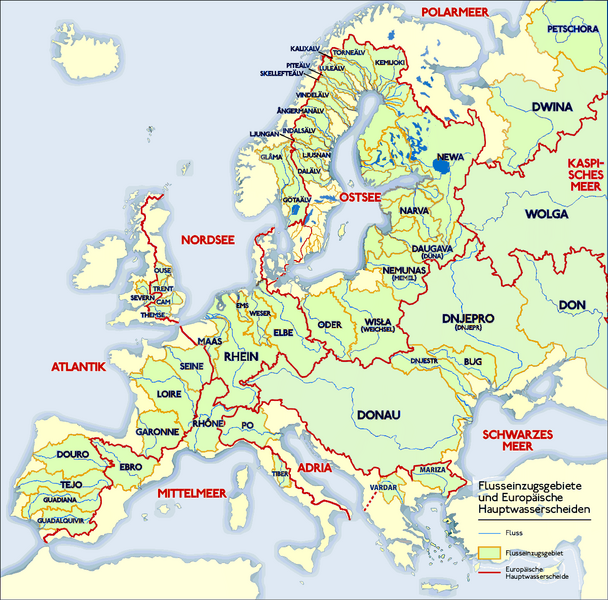
Deutsch: Grafik zeigt die Europäischen Flusseinzugsgebiete und Hauptwasserscheiden.
Zeichnung erstellt 06/2004 von Sansculotte. Bild ist unter der Creative Commons Share Alike zur weiteren Verwendung freigegeben. Quellenangabe und Beleg an sansculotte@despammed.com erbeten.English: The map shows the European rivers' catchment areas and main watersheds.
Chart made on 06/2004 by de:Sansculotte. The image is released under the Creative Commons Share Alike license for futher use. Reference and sources can be requested from sansculotte@despammed.comFrançais : Carte des bassins fluviaux d'Europe. Carte établie en juin 2004 par le contributeur de:Sansculotte
Sources (!) disponibles par demande à sansculotte@despammed.com
|
||||
| ⧼wm-license-information-date⧽ | 2004 | ||||
| ⧼wm-license-information-source⧽ | Source: German Wikipedia, original upload see file history | ||||
| ⧼wm-license-information-author⧽ | Sansculotte | ||||
| ⧼wm-license-information-permission⧽ (⧼wm-license-information-permission-reusing-text⧽) |
|
||||
| ⧼wm-license-information-other-versions⧽ |
|
||||


|
File history German Wikipedia
(Löschen) (Aktuell) 16:54, 15. Jan 2005 . . Sansculotte . . 1200x1184 (602233 Byte) (korr.)
(Löschen) (Zurücksetzen) 05:01, 3. Jun 2004 . . Sansculotte . . 1000x987 (262710 Byte) (eigene Darstellung, GNU FDL, Europäische Flußeinzugsgebiete und Hauptwasserscheiden)
(Löschen) (Zurücksetzen) 04:21, 3. Jun 2004 . . Sansculotte . . 1000x987 (183238 Byte) (eigene Darstellung, GNU FDL, Europäische Flußeinzugsgebiete und Hauptwasserscheiden)
تاريخ الملف
اضغط على زمن/تاريخ لرؤية الملف كما بدا في هذا الزمن.
| زمن/تاريخ | صورة مصغرة | الأبعاد | مستخدم | تعليق | |
|---|---|---|---|---|---|
| حالي | ★ مراجعة معتمدة 11:20، 29 نوفمبر 2023 | | 1٬200 × 1٬184 (526 كيلوبايت) | Pastakhov (نقاش | مساهمات) | Upload https://upload.wikimedia.org/wikipedia/commons/c/c4/Europ%C3%A4ische_Wasserscheiden.png |
لا يمكنك استبدال هذا الملف.
وصلات
لا يوجد صفحات تصل لهذه الصورة.