ملف:Egypt and Syria 1768 to 1774 map en.png
حجم هذه المعاينة: 771 × 600 بكسل. البعدان الآخران: 2٬560 × 1٬992 بكسل | 2٬792 × 2٬172 بكسل.
الملف الأصلي (2٬792 × 2٬172 بكسل حجم الملف: 873 كيلوبايت، نوع MIME: image/png)

|
[All images in this gallery should be recreated using vector graphics as an SVG file. This has several advantages; see Commons:Media for cleanup for more information. If an SVG form of this image is already available, please upload it. After uploading an SVG, replace this template with {{vector version available|new image name.svg}}.] Error: {{Lang}}: text has italic markup (help) |
|
العربية | български | català | čeština | dansk | Deutsch | English | Esperanto | español | français | galego | 한국어 | italiano | magyar | lietuvių | 日本語 | Plattdüütsch | Nederlands | norsk | polski | português | română | русский | suomi | svenska | Türkçe | українська | 中文(繁體) | 中文(简体) | +/− | |
وصف قصير
| ⧼wm-license-information-description⧽ |
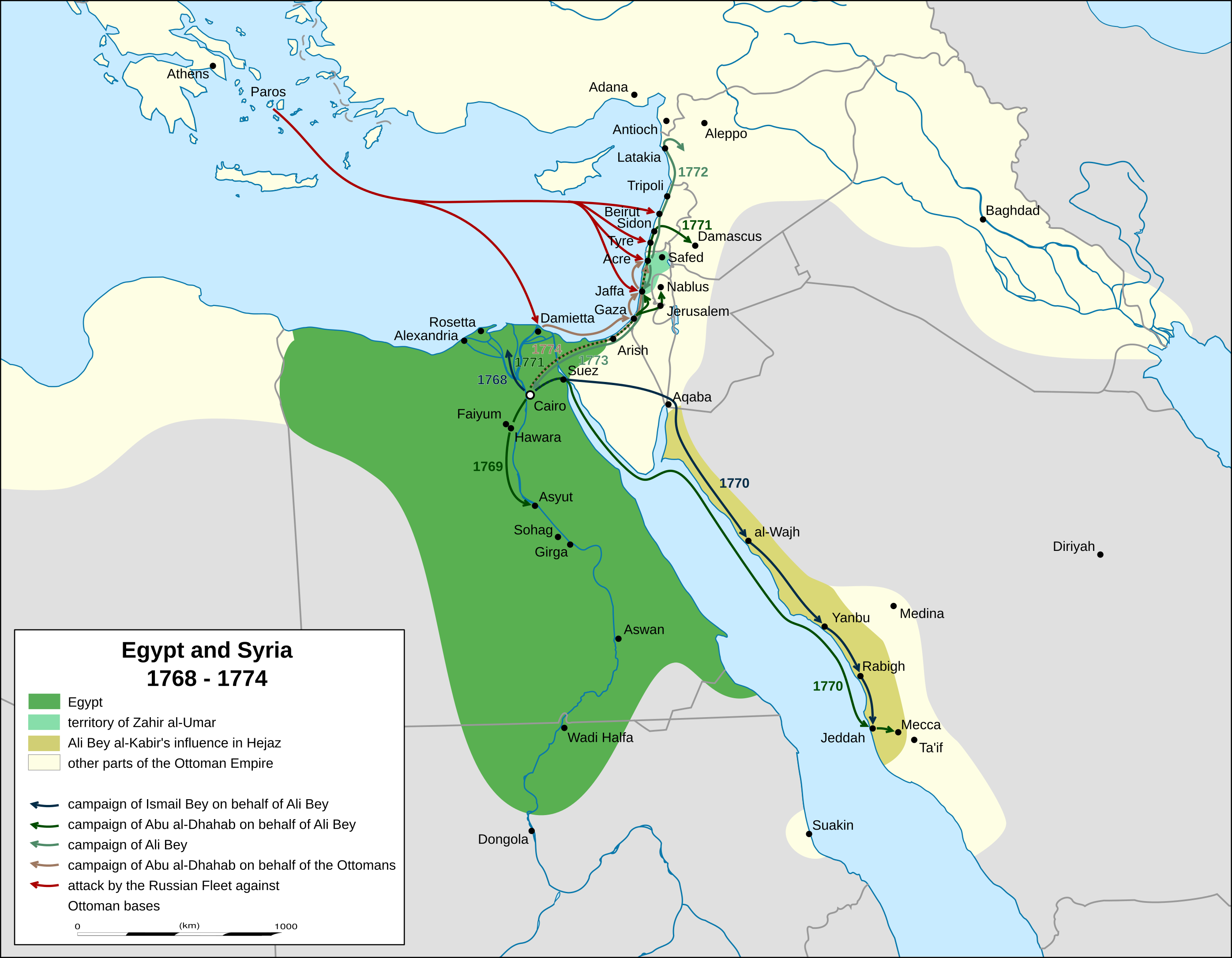
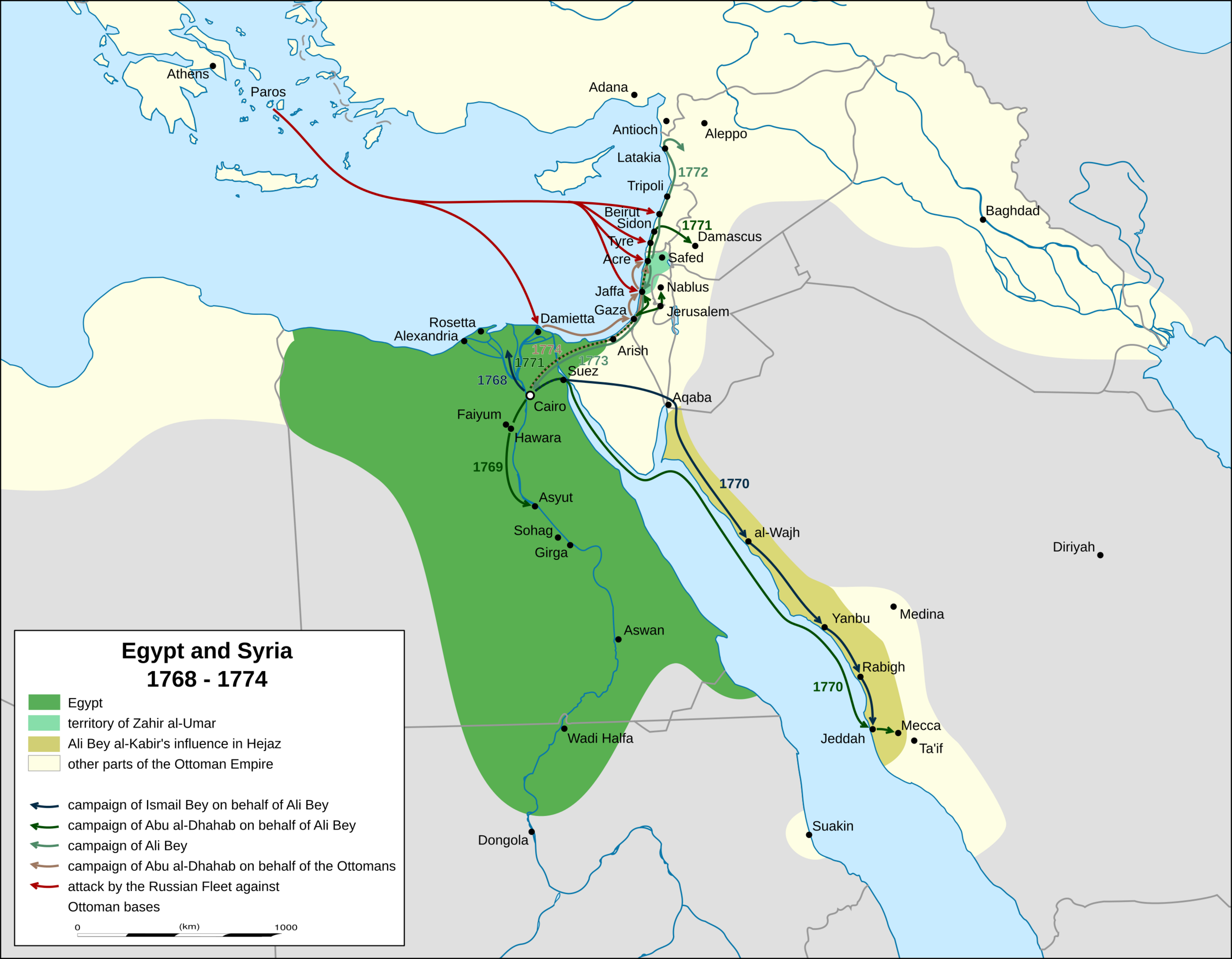
English: map of mamluk egypt, palestine and syria 1768 to 1774. campaigns and advances according to Sauveur Lusignan: A history of the Revolution of Ali Bey against the Ottoman Porte (London 1783) and Meyers Konversationslexikon, vol. 1, page 359 (Leipzig, 4th edition, 1885-1892)
|
| ⧼wm-license-information-date⧽ | 2018 |
| ⧼wm-license-information-source⧽ | ⧼Wm-license-own-work⧽, derivat of File:Africa location map.svg |
| ⧼wm-license-information-author⧽ | Don-kun, Eric Gaba (Sting - fr:Sting) |
| ⧼wm-license-information-other-versions⧽ |
ترخيص
|
|
هذا الملفُّ مُرخَّص بموجب رخصة المشاع الإبداعي نسبة المُصنَّف إِلى مؤلفه - المشاركة بالمثل 3.0 العامة. |
تاريخ الملف
اضغط على زمن/تاريخ لرؤية الملف كما بدا في هذا الزمن.
| زمن/تاريخ | صورة مصغرة | الأبعاد | مستخدم | تعليق | |
|---|---|---|---|---|---|
| حالي | ★ مراجعة معتمدة 09:08، 2 نوفمبر 2023 | | 2٬792 × 2٬172 (873 كيلوبايت) | Pastakhov (نقاش | مساهمات) | Upload https://upload.wikimedia.org/wikipedia/commons/1/12/Egypt_and_Syria_1768_to_1774_map_en.png |
لا يمكنك استبدال هذا الملف.
وصلات
لا يوجد صفحات تصل لهذه الصورة.