ملف:Duchy of Courland & Semigallia 1740.svg

حجم معاينة PNG لذلك الملف ذي الامتداد SVG: 681 × 599 بكسل. البعد الآخر: 2٬328 × 2٬048 بكسل.
الملف الأصلي (ملف SVG، أبعاده 1٬074 × 945 بكسل، حجم الملف: 510 كيلوبايت)
وصف قصير
| ⧼wm-license-information-description⧽ |
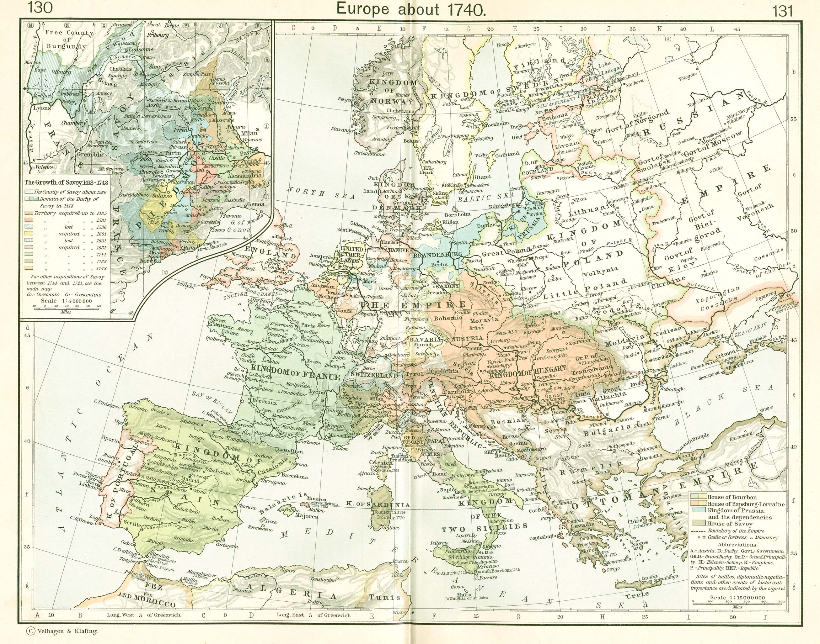
Français : Le duché de Courlande et Sémigalie en 1740.
English: The Duchy of Courland and Semigallia in 1740.
Polski: Księstwo Kurlandii i Semigalii w 1740 roku.
The towns and cities are designated by their German names since the nobility and the Duke were of German heritage. The rivers, somewhat incongruously, are given their common Latvian names. This map uses a Mercator projection. |
| ⧼wm-license-information-date⧽ | قالب:Original upload date |
| ⧼wm-license-information-source⧽ | No machine-readable source provided. Own work assumed (based on copyright claims). |
| ⧼wm-license-information-author⧽ | No machine-readable author provided. MapMaster assumed (based on copyright claims). |
| ⧼wm-license-information-other-versions⧽ |
|
References
The basic map was developed from Shepherd:
- Shepherd, William R., (1911), "Europe, 1740" in Historical Atlas, p. 131.
Modifications were made based on other resources including:
- Hammond Historical World Atlas, Hammond World Atlas Corporation, (2000).
Other versions
ترخيص
|

تاريخ الملف
اضغط على زمن/تاريخ لرؤية الملف كما بدا في هذا الزمن.
| زمن/تاريخ | صورة مصغرة | الأبعاد | مستخدم | تعليق | |
|---|---|---|---|---|---|
| حالي | ★ مراجعة معتمدة 22:09، 12 ديسمبر 2023 | | 1٬074 × 945 (510 كيلوبايت) | Pastakhov (نقاش | مساهمات) | Upload https://upload.wikimedia.org/wikipedia/commons/8/87/Duchy_of_Courland_%26_Semigallia_1740.svg |
لا يمكنك استبدال هذا الملف.
وصلات
لا يوجد صفحات تصل لهذه الصورة.