ملف:Dry line satellite description fr.svg

حجم معاينة PNG لذلك الملف ذي الامتداد SVG: 350 × 330 بكسل. البعد الآخر: 2٬172 × 2٬048 بكسل.
الملف الأصلي (ملف SVG، أبعاده 350 × 330 بكسل، حجم الملف: 166 كيلوبايت)
وصف قصير
| ⧼wm-license-information-description⧽ |
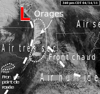
Français : Description des masses d'air de part et d'autre d'un front de point de rosée sur une photo satellitaire qui montre le dévelopement d'orages violents le 14 avril 2011.
|
| ⧼wm-license-information-date⧽ | 2011 |
| ⧼wm-license-information-source⧽ | قالب:Derived from |
| ⧼wm-license-information-author⧽ |
|
| [This is a retouched picture, which means that it has been digitally altered from its original version. The original can be viewed here: Dry line satellite description.png. Modifications made by Pierre_cb.] Error: {{Lang}}: text has italic markup (help)
|
ترخيص

|
تاريخ الملف
اضغط على زمن/تاريخ لرؤية الملف كما بدا في هذا الزمن.
| زمن/تاريخ | صورة مصغرة | الأبعاد | مستخدم | تعليق | |
|---|---|---|---|---|---|
| حالي | ★ مراجعة معتمدة 07:28، 18 نوفمبر 2023 | | 350 × 330 (166 كيلوبايت) | Pastakhov (نقاش | مساهمات) | Upload https://upload.wikimedia.org/wikipedia/commons/0/0a/Dry_line_satellite_description_fr.svg |
لا يمكنك استبدال هذا الملف.
وصلات
لا يوجد صفحات تصل لهذه الصورة.