ملف:Districts of Pakistan.png

حجم هذه المعاينة: 800 × 556 بكسل. البعد الآخر: 2٬720 × 1٬890 بكسل.
الملف الأصلي (2٬720 × 1٬890 بكسل حجم الملف: 352 كيلوبايت، نوع MIME: image/png)
وصف قصير
| ⧼wm-license-information-description⧽ |
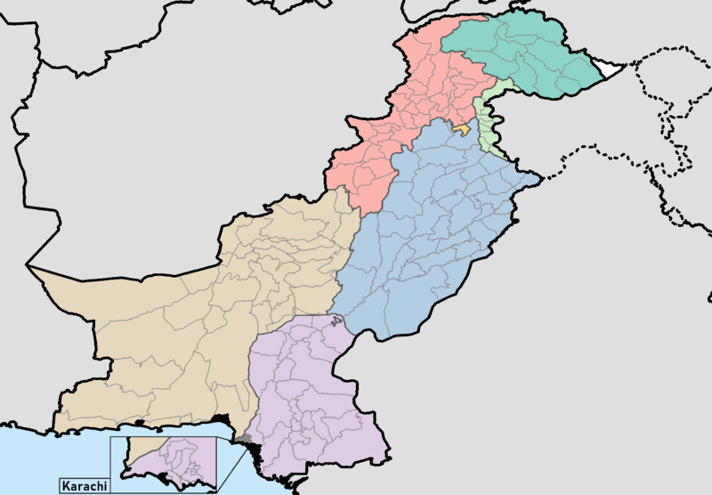
English: This is a map showing each and every district in Pakistan, including Azad Jammu & Kashmir and Gilgit-Baltistan. It was made using maps from the Pakistan Bureau of Statistics and UN OCHA's HumData Database (which citypopulation.de uses). It is up to date and shows each and every district in Balochistan, Azad Jammu & Kashmir, Khyber Pakhtunkhwa, Punjab, Sindh, and the ICT as of September 30, 2020. I haven't been able to find any official maps showing the borders of Gilgit-Baltistan's four new districts (specifically Darel District, Tangir District, Yaseen District, and Rondu District), so these are not depicted. Only the ten districts dating to the 2017 census are depicted. If anyone can find any official maps for these districts (all fourteen districts), let me know on my talk page and I'll update this map as promptly as I can.
A category full of these maps listed nicely can be found here. |
| ⧼wm-license-information-date⧽ | 2020 |
| ⧼wm-license-information-source⧽ | ⧼Wm-license-own-work⧽ |
| ⧼wm-license-information-author⧽ | User:Abbasi786786 |
.png&action=edit&redlink=1)
.png&action=edit&redlink=1)
.png&action=edit&redlink=1)
.png&action=edit&redlink=1)
ترخيص
|
تاريخ الملف
اضغط على زمن/تاريخ لرؤية الملف كما بدا في هذا الزمن.
| زمن/تاريخ | صورة مصغرة | الأبعاد | مستخدم | تعليق | |
|---|---|---|---|---|---|
| حالي | ★ مراجعة معتمدة 19:53، 13 أكتوبر 2023 | | 2٬720 × 1٬890 (352 كيلوبايت) | Pastakhov (نقاش | مساهمات) | Upload https://upload.wikimedia.org/wikipedia/commons/a/aa/Districts_of_Pakistan.png |
لا يمكنك استبدال هذا الملف.
وصلات
لا يوجد صفحات تصل لهذه الصورة.