ملف:Dioecesis Asiana 400 AD.png
لا توجد دقة أعلى متوفرة.
Dioecesis_Asiana_400_AD.png (609 × 392 بكسل حجم الملف: 249 كيلوبايت، نوع MIME: image/png)

|
[All images in this gallery should be recreated using vector graphics as an SVG file. This has several advantages; see Commons:Media for cleanup for more information. If an SVG form of this image is already available, please upload it. After uploading an SVG, replace this template with {{vector version available|new image name.svg}}.] Error: {{Lang}}: text has italic markup (help) |
|
العربية | български | català | čeština | dansk | Deutsch | English | Esperanto | español | français | galego | 한국어 | italiano | magyar | lietuvių | 日本語 | Plattdüütsch | Nederlands | norsk | polski | português | română | русский | suomi | svenska | Türkçe | українська | 中文(繁體) | 中文(简体) | +/− | |
وصف قصير
| ⧼wm-license-information-description⧽ |
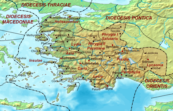
Map of the Diocese of Asia (Dioecesis Asiana) ca. 400 AD, showing the subordinate provinces and the major cities. |
| ⧼wm-license-information-date⧽ | 2007 |
| ⧼wm-license-information-source⧽ | Base map found at en:Topographic map#Global 1-kilometer map, otherwise self-made. Data based on maps in atlases and the internet and on contemporary sources, primarily the Notitia Dignitatum and the Synecdemus. Note: the exact course of the provincial boundaries is very uncertain and in many cases only approximate. |
| ⧼wm-license-information-author⧽ | Cplakidas |
ترخيص
تاريخ الملف
اضغط على زمن/تاريخ لرؤية الملف كما بدا في هذا الزمن.
| زمن/تاريخ | صورة مصغرة | الأبعاد | مستخدم | تعليق | |
|---|---|---|---|---|---|
| حالي | ★ مراجعة معتمدة 15:50، 18 أكتوبر 2023 | | 609 × 392 (249 كيلوبايت) | Pastakhov (نقاش | مساهمات) | Upload https://upload.wikimedia.org/wikipedia/commons/3/3d/Dioecesis_Asiana_400_AD.png |
لا يمكنك استبدال هذا الملف.
وصلات
لا يوجد صفحات تصل لهذه الصورة.