ملف:CrozetMapEst.png
لا توجد دقة أعلى متوفرة.
CrozetMapEst.png (390 × 274 بكسل حجم الملف: 39 كيلوبايت، نوع MIME: image/png)
وصف قصير
| ⧼wm-license-information-description⧽ |
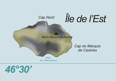
Deutsch: Karte der Île de l’Est, Crozetinseln, im südlichen Indischen Ozean
English: Map of Île de l’Est, Crozet Islands, in the Southern Indian Ocean
|
| ⧼wm-license-information-date⧽ | 2009 |
| ⧼wm-license-information-source⧽ | ⧼Wm-license-own-work⧽, based on original from Varp |
| ⧼wm-license-information-author⧽ | modified by Telim tor |
| ⧼wm-license-information-other-versions⧽ |
ترخيص
| [ This image has been (or is hereby) released into the public domain by its author, Varp at the wikimedia.commons project. This applies worldwide. In case this is not legally possible: Deutsch · Ελληνικά · English · Plattdüütsch · 中文(简体) · 中文(繁體) · +/− |
تاريخ الملف
اضغط على زمن/تاريخ لرؤية الملف كما بدا في هذا الزمن.
| زمن/تاريخ | صورة مصغرة | الأبعاد | مستخدم | تعليق | |
|---|---|---|---|---|---|
| حالي | ★ مراجعة معتمدة 22:37، 24 ديسمبر 2023 | | 390 × 274 (39 كيلوبايت) | Pastakhov (نقاش | مساهمات) | Upload https://upload.wikimedia.org/wikipedia/commons/1/14/CrozetMapEst.png |
لا يمكنك استبدال هذا الملف.
وصلات
لا يوجد صفحات تصل لهذه الصورة.