ملف:Copenhagen Metro with City Circle Line map.svg

حجم معاينة PNG لذلك الملف ذي الامتداد SVG: 512 × 335 بكسل. البعد الآخر: 2٬560 × 1٬675 بكسل.
الملف الأصلي (ملف SVG، أبعاده 512 × 335 بكسل، حجم الملف: 27 كيلوبايت)
| ⧼wm-license-information-description⧽ |
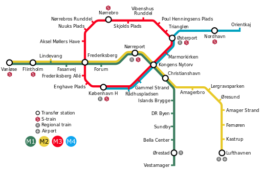
A map of the Copenhagen Metro with the City Circle Line intended to open in 2019 and the Nordhavn extension intended to open in 2020. Colours: M1=007F60, M2=FEC20F, M3=F8001F, M4=00A0BE |
| ⧼wm-license-information-date⧽ | 2009-11-17 11:27 (UTC) |
| ⧼wm-license-information-source⧽ | |
| ⧼wm-license-information-author⧽ |
|
|

قالب:Original upload log
This image is a derivative work of the following images:
- File:KøbenhavnMetroKort+Cityringen_English.svg licensed with Cc-by-sa-3.0,2.5,2.0,1.0, GFDL
- 2009-11-08T23:44:29Z Arsenikk 725x475 (84138 Bytes) Plain svg
- 2009-04-13T12:00:31Z Arsenikk 725x475 (84138 Bytes) {{Information |Description=A map of the Copenhagen Metro with the proposed City Circle Line intended to open in 2017–2018. |Source=*[[:File:KøbenhavnMetroKort+Cityringen.svg|]] |Date=2009-04-13 12:59 (UTC) |Author=*[[:File
تاريخ الملف
اضغط على زمن/تاريخ لرؤية الملف كما بدا في هذا الزمن.
| زمن/تاريخ | صورة مصغرة | الأبعاد | مستخدم | تعليق | |
|---|---|---|---|---|---|
| حالي | ★ مراجعة معتمدة 18:30، 1 ديسمبر 2023 | | 512 × 335 (27 كيلوبايت) | Pastakhov (نقاش | مساهمات) | Upload https://upload.wikimedia.org/wikipedia/commons/0/0d/Copenhagen_Metro_with_City_Circle_Line_map.svg |
لا يمكنك استبدال هذا الملف.
وصلات
لا يوجد صفحات تصل لهذه الصورة.