ملف:Comox BC aerial view.jpg

حجم هذه المعاينة: 800 × 272 بكسل. البعد الآخر: 1٬806 × 614 بكسل.
الملف الأصلي (1٬806 × 614 بكسل حجم الملف: 305 كيلوبايت، نوع MIME: image/jpeg)
وصف قصير
| ⧼wm-license-information-description⧽ |
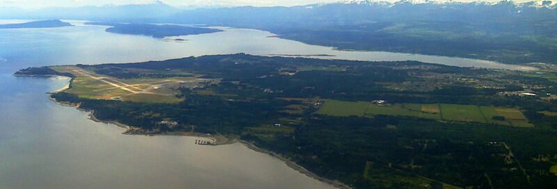
English: The town of Comox, British Columbia, and environs as seen from the north. The peninsula on which Comox sits is surrounded on three sides by water: to the west (right), the Courtenay River Estuary; to the south (straight ahead), Comox Bay; and to the east (left), the Strait of Georgia. Comox enjoys a temperate climate as a result. The airport of CFB Comox, also used by commercial aircraft, can be seen on the left side of the peninsula. The town of Comox itself is on the shore of Comox Bay, protected from prevailing south-easterly winds by the sandy hook of the Goose Spit. Denman and Hornby Islands can be seen to the south, and the Beaufort Mountain Range of Vancouver Island extends into the distance.
|
| ⧼wm-license-information-date⧽ | 2011 |
| ⧼wm-license-information-source⧽ | ⧼Wm-license-own-work⧽ |
| ⧼wm-license-information-author⧽ | Guinness323 |
ترخيص
|
تاريخ الملف
اضغط على زمن/تاريخ لرؤية الملف كما بدا في هذا الزمن.
| زمن/تاريخ | صورة مصغرة | الأبعاد | مستخدم | تعليق | |
|---|---|---|---|---|---|
| حالي | ★ مراجعة معتمدة 00:33، 3 نوفمبر 2023 | 1٬806 × 614 (305 كيلوبايت) | Pastakhov (نقاش | مساهمات) | Upload https://upload.wikimedia.org/wikipedia/commons/9/92/Comox_BC_aerial_view.jpg |
لا يمكنك استبدال هذا الملف.
وصلات
الصفحات التالية تحتوي على وصلة لهذه الصورة:
تصنيفات:
- Self-published work
- Aerial photographs of Vancouver Island
- Comox, British Columbia
- Aerial photographs of Hornby Island
- Aerial photographs of Denman Island
- 2011 aerial photographs of Canada
- CFB Comox
- Aerial photographs of airports in British Columbia
- July 2011 in British Columbia
- Canada photographs taken on 2011-07-06