ملف:Commercial Road, Limehouse - geograph.org.uk - 2441228.jpg
لا توجد دقة أعلى متوفرة.
Commercial_Road,_Limehouse_-_geograph.org.uk_-_2441228.jpg (640 × 480 بكسل حجم الملف: 75 كيلوبايت، نوع MIME: image/jpeg)
وصف قصير
| ⧼wm-license-information-description⧽ |
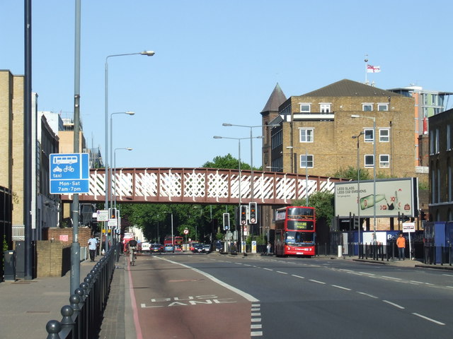
English: Commercial Road in Limehouse, East London. This road, which is designated as the A13, used to be the main road heading eastwards out of London towards Southend, but much of the traffic now bypasses this area using new tunnels on the A1203. The railway bridge in the background is disused.
|
| ⧼wm-license-information-date⧽ | 2011 |
| ⧼wm-license-information-source⧽ | From geograph.org.uk; transferred by User:Ultra7 using geograph_org2commons. |
| ⧼wm-license-information-author⧽ | Malc McDonald |
| ⧼wm-license-information-permission⧽ (⧼wm-license-information-permission-reusing-text⧽) |
Creative Commons Attribution Share-alike license 2.0 |
| ⧼wm-license-cc-attribution⧽ (قالب:I18n/Credit line) |
Malc McDonald / Commercial Road, Limehouse / |
قالب:Location dec قالب:Object location
ترخيص
تاريخ الملف
اضغط على زمن/تاريخ لرؤية الملف كما بدا في هذا الزمن.
| زمن/تاريخ | صورة مصغرة | الأبعاد | مستخدم | تعليق | |
|---|---|---|---|---|---|
| حالي | ★ مراجعة معتمدة 01:35، 14 أكتوبر 2023 | | 640 × 480 (75 كيلوبايت) | Pastakhov (نقاش | مساهمات) | Upload https://upload.wikimedia.org/wikipedia/commons/3/32/Commercial_Road%2C_Limehouse_-_geograph.org.uk_-_2441228.jpg |
لا يمكنك استبدال هذا الملف.
وصلات
لا يوجد صفحات تصل لهذه الصورة.
تصنيفات:
- Commercial Road, London
- Railway bridges in the London Borough of Tower Hamlets
- Images by Malc McDonald
- Buses in Limehouse
- Buses in the London Borough of Tower Hamlets
- June 2011 in London
- 2011 in the London Borough of Tower Hamlets
- Bridges in London photographed in 2011
- United Kingdom photographs taken on 2011-06-03