ملف:Chowanrivermap.png
لا توجد دقة أعلى متوفرة.
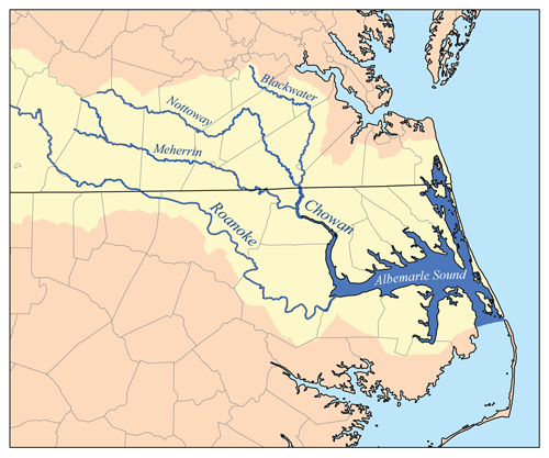
Chowanrivermap.png (500 × 417 بكسل حجم الملف: 156 كيلوبايت، نوع MIME: image/png)
وصف قصير
| ⧼wm-license-information-description⧽ |
This is a map of eastern portion of the Chowan/Roanoke watershed, showing the Chowan, Meherrin, Nottoway and Blackwater rivers as well as Albemarle Sound. For the western portion of the watershed see Image:RoanokeRiverWatershed.png. I, Karl Musser, created it based on USGS data. |
| ⧼wm-license-information-date⧽ | قالب:Original upload date |
| ⧼wm-license-information-source⧽ | No machine-readable source provided. Own work assumed (based on copyright claims). |
| ⧼wm-license-information-author⧽ | No machine-readable author provided. Kmusser assumed (based on copyright claims). |
ترخيص
تاريخ الملف
اضغط على زمن/تاريخ لرؤية الملف كما بدا في هذا الزمن.
| زمن/تاريخ | صورة مصغرة | الأبعاد | مستخدم | تعليق | |
|---|---|---|---|---|---|
| حالي | ★ مراجعة معتمدة 01:45، 31 أكتوبر 2023 | | 500 × 417 (156 كيلوبايت) | Pastakhov (نقاش | مساهمات) | Upload https://upload.wikimedia.org/wikipedia/commons/e/e1/Chowanrivermap.png |
لا يمكنك استبدال هذا الملف.
وصلات
لا يوجد صفحات تصل لهذه الصورة.