ملف:Celtic Sea and Bay of Biscay bathymetric map-en.svg

حجم معاينة PNG لذلك الملف ذي الامتداد SVG: 548 × 599 بكسل. البعد الآخر: 1٬872 × 2٬048 بكسل.
الملف الأصلي (ملف SVG، أبعاده 3٬479 × 3٬805 بكسل، حجم الملف: 4٫93 ميجابايت)
وصف قصير
قالب:Igen
| ⧼wm-license-information-description⧽ |
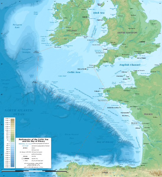
English: Bathymetric map in English of the Celtic Sea and the Bay of Biscay. Limits of the seas as specified by the International Hydrographic Organization.
Note: the background map is a raster image embedded in the SVG file. Français : Carte bathymétrique en anglais de la Mer Celtique et du Golfe de Gascogne. Limites des mers telles que définies par l'Organisation Hydrographique Internationale.
Note : le fond de carte est une image bitmap embarquée dans le fichier SVG. |
| ⧼wm-license-information-date⧽ | 2014-07-01 13:37:01, upgraded 2019-10 |
| ⧼wm-license-information-source⧽ | see قالب:F |
| ⧼wm-license-information-author⧽ | Eric Gaba (Sting - fr:Sting) |
| ⧼wm-license-information-other-versions⧽ |
قالب:Other versions/Celtic Sea and Bay of Biscay bathymetric map |
49°00′00″N 7°00′00″W / 49.00000°N 7.00000°W
ترخيص
|
|
هذا الملفُّ مُرخَّص بموجب رخصة المشاع الإبداعي نسبة المُصنَّف إِلى مؤلفه - المشاركة بالمثل 3.0 العامة. |
تاريخ الملف
اضغط على زمن/تاريخ لرؤية الملف كما بدا في هذا الزمن.
| زمن/تاريخ | صورة مصغرة | الأبعاد | مستخدم | تعليق | |
|---|---|---|---|---|---|
| حالي | ★ مراجعة معتمدة 12:51، 16 أكتوبر 2023 | | 3٬479 × 3٬805 (4٫93 ميجابايت) | Pastakhov (نقاش | مساهمات) | Upload https://upload.wikimedia.org/wikipedia/commons/c/c1/Celtic_Sea_and_Bay_of_Biscay_bathymetric_map-en.svg |
لا يمكنك استبدال هذا الملف.
وصلات
لا يوجد صفحات تصل لهذه الصورة.