ملف:Carte calanques marseille.jpg

حجم هذه المعاينة: 800 × 204 بكسل. البعد الآخر: 3٬307 × 844 بكسل.
الملف الأصلي (3٬307 × 844 بكسل حجم الملف: 170 كيلوبايت، نوع MIME: image/jpeg)
وصف قصير

|
[All images in this gallery should be recreated using vector graphics as an SVG file. This has several advantages; see Commons:Media for cleanup for more information. If an SVG form of this image is already available, please upload it. After uploading an SVG, replace this template with {{vector version available|new image name.svg}}.] Error: {{Lang}}: text has italic markup (help) |
|
العربية | български | català | čeština | dansk | Deutsch | English | Esperanto | español | français | galego | 한국어 | italiano | magyar | lietuvių | 日本語 | Plattdüütsch | Nederlands | norsk | polski | português | română | русский | suomi | svenska | Türkçe | українська | 中文(繁體) | 中文(简体) | +/− | |
| ⧼wm-license-information-description⧽ |
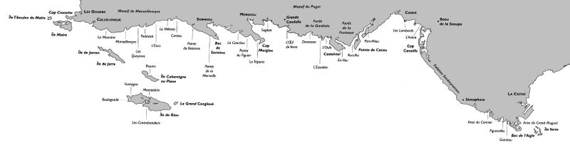
Carte des fr:Calanques entre fr:Marseille et fr:La Ciotat |
| ⧼wm-license-information-date⧽ | قالب:Original upload date |
| ⧼wm-license-information-source⧽ | قالب:Transferred from |
| ⧼wm-license-information-author⧽ | قالب:Original uploader |
ترخيص

|
قالب:Original upload log
قالب:Original description page
- 2005-05-07 23:45 Christophe.moustier 3307×844×8 (173581 bytes) Carte des [[Calanques]] entre [[Marseille]] et [[Casis]] {{GFDL}}
تاريخ الملف
اضغط على زمن/تاريخ لرؤية الملف كما بدا في هذا الزمن.
| زمن/تاريخ | صورة مصغرة | الأبعاد | مستخدم | تعليق | |
|---|---|---|---|---|---|
| حالي | ★ مراجعة معتمدة 20:39، 16 أكتوبر 2023 | 3٬307 × 844 (170 كيلوبايت) | Pastakhov (نقاش | مساهمات) | Upload https://upload.wikimedia.org/wikipedia/commons/8/8b/Carte_calanques_marseille.jpg |
لا يمكنك استبدال هذا الملف.
وصلات
الصفحات التالية تحتوي على وصلة لهذه الصورة: