ملف:Cape Gracias a Dios.jpg

حجم هذه المعاينة: 375 × 600 بكسل. البعد الآخر: 1٬200 × 1٬920 بكسل.
الملف الأصلي (1٬200 × 1٬920 بكسل حجم الملف: 1٫46 ميجابايت، نوع MIME: image/jpeg)
وصف قصير
| ⧼wm-license-information-description⧽ |
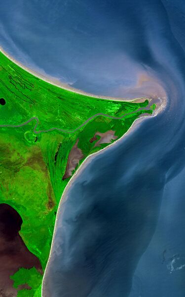
Around 15 degrees North, a rounded point of land juts out into the Caribbean Sea from the Central American isthmus. This low-lying, wet area is called the Mosquito Coast, a corruption of the tribal name of some of the area’s native people, the Miskito. The area includes parts of Honduras (north) and Nicaragua (south). Between the two countries flows the Coco River, which empties into the Caribbean at Cape Gracias á Dios. |
| ⧼wm-license-information-date⧽ | 2002 |
| ⧼wm-license-information-source⧽ | http://earthobservatory.nasa.gov/Newsroom/NewImages/images.php3?img_id=17232
|
| ⧼wm-license-information-author⧽ | NASA/GSFC/METI/ERSDAC/JAROS, and U.S./Japan ASTER Science Team |
ترخيص
تاريخ الملف
اضغط على زمن/تاريخ لرؤية الملف كما بدا في هذا الزمن.
| زمن/تاريخ | صورة مصغرة | الأبعاد | مستخدم | تعليق | |
|---|---|---|---|---|---|
| حالي | ★ مراجعة معتمدة 09:10، 16 أكتوبر 2023 | | 1٬200 × 1٬920 (1٫46 ميجابايت) | Pastakhov (نقاش | مساهمات) | Upload https://upload.wikimedia.org/wikipedia/commons/f/f2/Cape_Gracias_a_Dios.jpg |
لا يمكنك استبدال هذا الملف.
وصلات
الصفحات التالية تحتوي على وصلة لهذه الصورة:
- ساحل موسكيتو
- ملف:Mosquito coast.jpg (تحويلة ملف)