ملف:COVID-19 Outbreak Cases in Ireland.svg

حجم معاينة PNG لذلك الملف ذي الامتداد SVG: 400 × 500 بكسل. البعد الآخر: 1٬638 × 2٬048 بكسل.
الملف الأصلي (ملف SVG، أبعاده 400 × 500 بكسل، حجم الملف: 204 كيلوبايت)
وصف قصير
| ⧼wm-license-information-description⧽ |
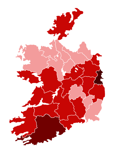
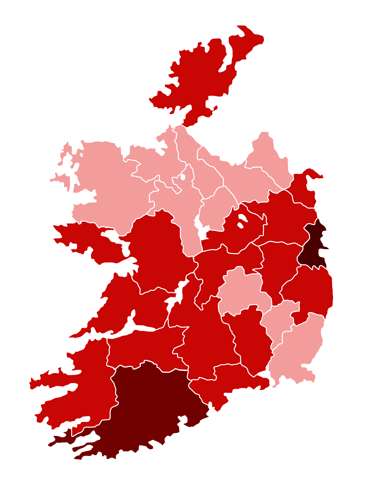
English: Map of the COVID-19 outbreak in Ireland as of 17 March 2020. Be aware that since this is a rapidly evolving situation, new cases may not be immediately represented visually. Refer to the primary article 2020 coronavirus outbreak in Europe or the World Health Organization's situation reports for most recent reported case information.
Map of the pandemic in Ireland 100+ confirmed cases
11–99 confirmed cases
1–10 confirmed cases Carlow < = 5 Cavan < = 5 Clare < = 5 Donegal < = 5 Kilkenny < = 5 Laoise < = 5 Leitrim < = 5 Longford < = 5 Mayo < = 5 Offaly < = 5 Roscommon < = 5 Sligo < = 5 Tipperary < = 5 Wexford < = 5 Kildare 6 Louth 6 Meath 6 Kerry 6 Waterford 7 Westmeath 7 Wicklow 13 Galway 13 Limerick 14 Cork 62 Dublin 172 |
| ⧼wm-license-information-date⧽ | |
| ⧼wm-license-information-source⧽ | |
| ⧼wm-license-information-author⧽ |
ترخيص
|
تاريخ الملف
اضغط على زمن/تاريخ لرؤية الملف كما بدا في هذا الزمن.
| زمن/تاريخ | صورة مصغرة | الأبعاد | مستخدم | تعليق | |
|---|---|---|---|---|---|
| حالي | ★ مراجعة معتمدة 09:26، 25 أكتوبر 2023 | | 400 × 500 (204 كيلوبايت) | Pastakhov (نقاش | مساهمات) | Upload https://upload.wikimedia.org/wikipedia/commons/3/38/COVID-19_Outbreak_Cases_in_Ireland.svg |
لا يمكنك استبدال هذا الملف.
وصلات
لا يوجد صفحات تصل لهذه الصورة.