ملف:COVID-19 Cases in Washington (state) by counties.svg

حجم معاينة PNG لذلك الملف ذي الامتداد SVG: 512 × 333 بكسل. البعد الآخر: 2٬560 × 1٬665 بكسل.
الملف الأصلي (ملف SVG، أبعاده 512 × 333 بكسل، حجم الملف: 231 كيلوبايت)
وصف قصير
| ⧼wm-license-information-description⧽ |
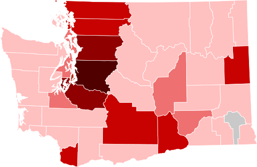
English: Map of confirmed cases in the state of Washington by counties as of 23 April 2020. Note that this map might be not up to date, as this is a current outbreak.
5,000+ confirmed cases
1000–4999 confirmed cases
250–999 confirmed cases
95–249 confirmed cases
1–94 confirmed cases |
| ⧼wm-license-information-date⧽ | 2020 |
| ⧼wm-license-information-source⧽ | File:Washington_Democratic_Presidential_Caucuses_Election_Results_by_County,_2016.svg |
| ⧼wm-license-information-author⧽ | Pharexia, Ali Zifan/Oganesson007, Moityl |
ترخيص
تاريخ الملف
اضغط على زمن/تاريخ لرؤية الملف كما بدا في هذا الزمن.
| زمن/تاريخ | صورة مصغرة | الأبعاد | مستخدم | تعليق | |
|---|---|---|---|---|---|
| حالي | ★ مراجعة معتمدة 22:30، 1 نوفمبر 2023 | | 512 × 333 (231 كيلوبايت) | Pastakhov (نقاش | مساهمات) | Upload https://upload.wikimedia.org/wikipedia/commons/4/48/COVID-19_Cases_in_Washington_%28state%29_by_counties.svg |
لا يمكنك استبدال هذا الملف.
وصلات
لا يوجد صفحات تصل لهذه الصورة.
_by_counties.svg&oldid=3324770)