ملف:COVID-19 Cases in Ohio by counties 2.svg

حجم معاينة PNG لذلك الملف ذي الامتداد SVG: 551 × 599 بكسل. البعد الآخر: 1٬884 × 2٬048 بكسل.
الملف الأصلي (ملف SVG، أبعاده 3٬675 × 3٬995 بكسل، حجم الملف: 154 كيلوبايت)
وصف قصير
| ⧼wm-license-information-description⧽ |
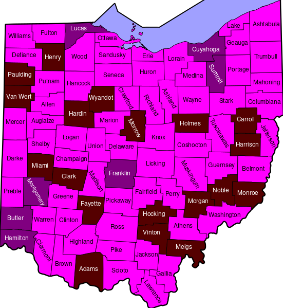
English: Map of COVID 19 by county in Ohio
>100,000 confirmed cases
10,000 - 99,999 confirmed cases
1,000-9,999 confirmed cases
100-999 confirmed cases
10-99 confirmed cases
1–9 confirmed cases |
| ⧼wm-license-information-date⧽ | 2020 |
| ⧼wm-license-information-source⧽ | File:US Presidential Election Results in Ohio by County, 1972.svg, Template:COVID-19 pandemic data/Ohio medical cases by county |
| ⧼wm-license-information-author⧽ | Oogle12, Ibagli (original map) |
ترخيص
|
تاريخ الملف
اضغط على زمن/تاريخ لرؤية الملف كما بدا في هذا الزمن.
| زمن/تاريخ | صورة مصغرة | الأبعاد | مستخدم | تعليق | |
|---|---|---|---|---|---|
| حالي | ★ مراجعة معتمدة 01:18، 2 نوفمبر 2023 | | 3٬675 × 3٬995 (154 كيلوبايت) | Pastakhov (نقاش | مساهمات) | Upload https://upload.wikimedia.org/wikipedia/commons/1/1f/COVID-19_Cases_in_Ohio_by_counties_2.svg |
لا يمكنك استبدال هذا الملف.
وصلات
لا يوجد صفحات تصل لهذه الصورة.