ملف:Brooklands Metrolink Station - geograph.org.uk - 526331.jpg
لا توجد دقة أعلى متوفرة.
Brooklands_Metrolink_Station_-_geograph.org.uk_-_526331.jpg (640 × 353 بكسل حجم الملف: 91 كيلوبايت، نوع MIME: image/jpeg)
وصف قصير
| ⧼wm-license-information-description⧽ |
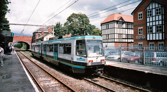
English: Brooklands Metrolink Station Brooklands Station was originally opened on 1st December 1859 as part of the Manchester, South Junction and Altrincham Railway, which on 1st January 1948 became part of British Rail's London Midland Region following nationalisation.
The last day of operation by British Rail was Christmas Eve 1991, and the Station re-opened on Monday 15th June 1992 as part of the Manchester Metrolink tram network. Pictured above is Light Rail Vehicle No. 1014 at Brooklands Station on Sunday 1st July 2007 which was the last day of tram operation between Manchester and Altrincham before a scheduled eight week closedown for track renewal work. |
| ⧼wm-license-information-date⧽ | 2007 |
| ⧼wm-license-information-source⧽ | From geograph.org.uk |
| ⧼wm-license-information-author⧽ | Manchester Warrior |
| ⧼wm-license-cc-attribution⧽ (قالب:I18n/Credit line) |
Manchester Warrior / Brooklands Metrolink Station / |
53°24′58″N 2°19′40″W / 53.41621°N 2.3277°W قالب:Object location
_heading:67)
ترخيص
تاريخ الملف
اضغط على زمن/تاريخ لرؤية الملف كما بدا في هذا الزمن.
| زمن/تاريخ | صورة مصغرة | الأبعاد | مستخدم | تعليق | |
|---|---|---|---|---|---|
| حالي | ★ مراجعة معتمدة 04:58، 13 أكتوبر 2023 | | 640 × 353 (91 كيلوبايت) | Pastakhov (نقاش | مساهمات) | Upload https://upload.wikimedia.org/wikipedia/commons/d/d7/Brooklands_Metrolink_Station_-_geograph.org.uk_-_526331.jpg |
لا يمكنك استبدال هذا الملف.
وصلات
لا يوجد صفحات تصل لهذه الصورة.