ملف:Broadgate and Precincts - geograph.org.uk - 554599.jpg
لا توجد دقة أعلى متوفرة.
Broadgate_and_Precincts_-_geograph.org.uk_-_554599.jpg (640 × 480 بكسل حجم الملف: 96 كيلوبايت، نوع MIME: image/jpeg)
وصف قصير
| ⧼wm-license-information-description⧽ |
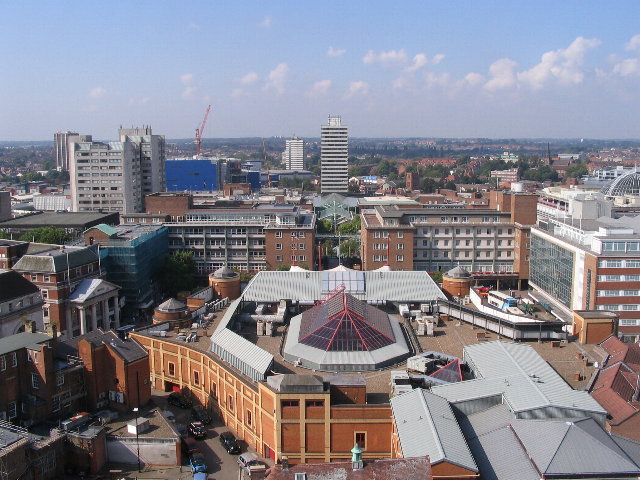
English: Broadgate and Precincts Taken from the tower of the old cathedral church of St. Michael, looking westwards down the line of the Upper and Lower Precinct shopping areas towards Mercia House[1], the tower block at the bottom end of the Lower Precinct. To the right of Mercia House is the red sandstone tower of St John's Church. To its left a little further into the distance is the Skydome and Odeon complex in Spon Street, partially obscured by the blue blob of Ikea. The grey tower block to the left is Coventry Point in Market Way. In the foreground is the roof of the Cathedral Lanes shopping centre swamping Broadgate. Left foreground is Pepper Lane, running towards High Street.
To see how it looked in 1975, see https://www.geograph.org.uk/photo/156892 and 1983 : https://www.geograph.org.uk/photo/1059854 . |
| ⧼wm-license-information-date⧽ | 2007 |
| ⧼wm-license-information-source⧽ | From geograph.org.uk |
| ⧼wm-license-information-author⧽ | E Gammie |
| ⧼wm-license-cc-attribution⧽ (قالب:I18n/Credit line) |
E Gammie / Broadgate and Precincts / |
52°24′29″N 1°30′30″W / 52.40803°N 1.5082°W قالب:Object location
_heading:270)
ترخيص
تاريخ الملف
اضغط على زمن/تاريخ لرؤية الملف كما بدا في هذا الزمن.
| زمن/تاريخ | صورة مصغرة | الأبعاد | مستخدم | تعليق | |
|---|---|---|---|---|---|
| حالي | ★ مراجعة معتمدة 11:00، 4 نوفمبر 2023 | | 640 × 480 (96 كيلوبايت) | Pastakhov (نقاش | مساهمات) | Upload https://upload.wikimedia.org/wikipedia/commons/2/27/Broadgate_and_Precincts_-_geograph.org.uk_-_554599.jpg |
لا يمكنك استبدال هذا الملف.
وصلات
لا يوجد صفحات تصل لهذه الصورة.