ملف:Belle Fourche River 19A.JPG
حجم هذه المعاينة: 800 × 533 بكسل. البعد الآخر: 849 × 566 بكسل.
الملف الأصلي (849 × 566 بكسل حجم الملف: 316 كيلوبايت، نوع MIME: image/jpeg)
وصف قصير
Belle Fourche River
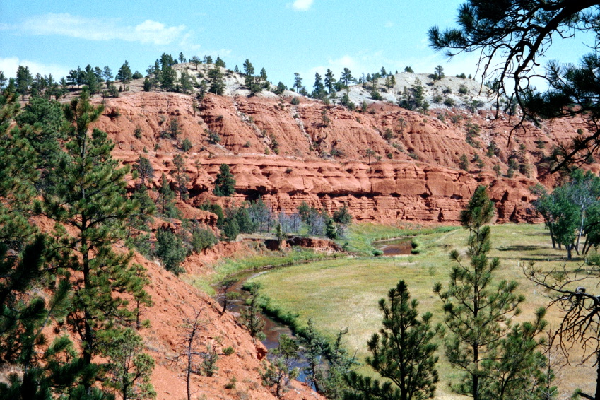
- Description: Pinus ponderosa on dark red sandstone and maroon siltstone, interbedded with shale (not visible), along the Belle Fourche River, Spearfish Formation, Triassic. The greyish beds visible on top belong to the overlying Gypsum Spring Formation, Jurassic.
- Viewpoint location: Red Beds Trail 300 meters north of the Highway 110 bridge across the Belle Fourche River, Devils Tower National Monument
- Viewpoint elevation: 3940 ft.
- View direction: Northeast
- Date and time: 2000.09.09 late morning
- Camera: Olympus 35 mm film
- Photographer: Walter Siegmund
©2005 Walter Siegmund
ترخيص
قالب:Cc-by-sa-3.0-migrated |

تاريخ الملف
اضغط على زمن/تاريخ لرؤية الملف كما بدا في هذا الزمن.
| زمن/تاريخ | صورة مصغرة | الأبعاد | مستخدم | تعليق | |
|---|---|---|---|---|---|
| حالي | ★ مراجعة معتمدة 08:47، 6 أكتوبر 2023 | | 849 × 566 (316 كيلوبايت) | Pastakhov (نقاش | مساهمات) | Upload https://upload.wikimedia.org/wikipedia/commons/e/ec/Belle_Fourche_River_19A.JPG |
لا يمكنك استبدال هذا الملف.
وصلات
لا يوجد صفحات تصل لهذه الصورة.
معلومات الصورة (ميتا)
تصنيفات:
- Self-published work
- Sandstone formations in the United States
- Siltstone
- Rock formations in Wyoming
- Belle Fourche River
- Media missing infobox template
- Sedimentary rocks in Wyoming
- Spearfish Formation
- Gypsum Springs Formation
- Stratigraphy of Wyoming
- September 2000 in Wyoming
- Pinus ponderosa subsp. scopulorum
- Pinus in Wyoming