ملف:Belagerung Kaiserswerth 1702.jpg
حجم هذه المعاينة: 800 × 577 بكسل. البعد الآخر: 850 × 613 بكسل.
الملف الأصلي (850 × 613 بكسل حجم الملف: 184 كيلوبايت، نوع MIME: image/jpeg)
وصف قصير
| ⧼wm-license-information-description⧽ |
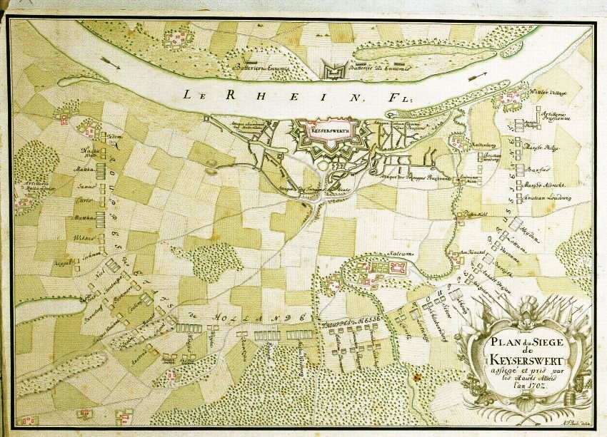
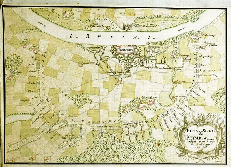
Deutsch: Originaltitel: Plan du siege de Keyserswert assiegé et pris par les Hauts Allieés l'an 1702; Dargestellt wird die Belagerung von Kaiserswerth durch holländische und preußische Truppen im Jahr 1702. Der Plan ist nach Westen ausgerichtet und zeigt den den Grundriss von Kaiserswerth mit den Stellungen und Namen der Regimenter sowie das Ortslager bei Kalkum (kolorierte Handzeichnung)
|
| ⧼wm-license-information-date⧽ | 1702 |
| ⧼wm-license-information-source⧽ | Digitales Archiv Marburg |
| ⧼wm-license-information-author⧽ | style="background: #E4E4E4; color: black; vertical-align: middle; text-align: center; " class="unknown table-unknown"|author |
ترخيص
|
|
This file is in the ملكية عامة because its copyright has expired in the United States and those countries with a copyright term of no more than the life of the author plus 100 years.
|
تاريخ الملف
اضغط على زمن/تاريخ لرؤية الملف كما بدا في هذا الزمن.
| زمن/تاريخ | صورة مصغرة | الأبعاد | مستخدم | تعليق | |
|---|---|---|---|---|---|
| حالي | ★ مراجعة معتمدة 20:26، 12 أكتوبر 2023 | | 850 × 613 (184 كيلوبايت) | Pastakhov (نقاش | مساهمات) | Upload https://upload.wikimedia.org/wikipedia/commons/e/ef/Belagerung_Kaiserswerth_1702.jpg |
لا يمكنك استبدال هذا الملف.
وصلات
لا يوجد صفحات تصل لهذه الصورة.