ملف:Bathymetry of the northeast corner of the Caribbean Plate showing the major faults and plate boundaries.jpg

حجم هذه المعاينة: 800 × 480 بكسل. البعد الآخر: 1٬500 × 900 بكسل.
الملف الأصلي (1٬500 × 900 بكسل حجم الملف: 382 كيلوبايت، نوع MIME: image/jpeg)
وصف قصير
| ⧼wm-license-information-description⧽ |
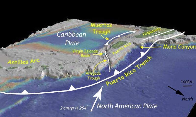
English: Bathymetry of the northeast corner of the Caribbean Plate showing the major faults and plate boundaries; view looking south-west. The main bathymetric features of this area include: the Lesser Antilles volcanic arc; the old inactive volcanic arc of the Greater Antilles (Virgin Islands, Puerto Rico, and Hispaniola); the Muertos Trough; and the Puerto Rico Trench formed at the plate boundary zone between the Caribbean and obliquely subducting North American Plates. Vertical exaggeration is 5:1. Bathymetry data generated using the Global Multi-Resolution Topography (GMRT) synthesis in GeoMapApp.
English: Batimetría de la esquina noreste de la placa caribeña, demonstrando la fallas mayores y los borders de la placa.
|
| ⧼wm-license-information-date⧽ | 2014, {{time}} – invalid date format 05 (help) |
| ⧼wm-license-information-source⧽ | NOAA http://oceanexplorer.noaa.gov/okeanos/explorations/ex1502/background/geology/welcome.html |
| ⧼wm-license-information-author⧽ | NOAA |
ترخيص

|
تاريخ الملف
اضغط على زمن/تاريخ لرؤية الملف كما بدا في هذا الزمن.
| زمن/تاريخ | صورة مصغرة | الأبعاد | مستخدم | تعليق | |
|---|---|---|---|---|---|
| حالي | ★ مراجعة معتمدة 13:26، 4 نوفمبر 2023 | | 1٬500 × 900 (382 كيلوبايت) | Pastakhov (نقاش | مساهمات) | Upload https://upload.wikimedia.org/wikipedia/commons/3/39/Bathymetry_of_the_northeast_corner_of_the_Caribbean_Plate_showing_the_major_faults_and_plate_boundaries.jpg |
لا يمكنك استبدال هذا الملف.
وصلات
لا يوجد صفحات تصل لهذه الصورة.