ملف:Ballygawley Co. Tyrone - geograph.org.uk - 62151.jpg
لا توجد دقة أعلى متوفرة.
Ballygawley_Co._Tyrone_-_geograph.org.uk_-_62151.jpg (512 × 383 بكسل حجم الملف: 71 كيلوبايت، نوع MIME: image/jpeg)
وصف قصير
| ⧼wm-license-information-description⧽ |
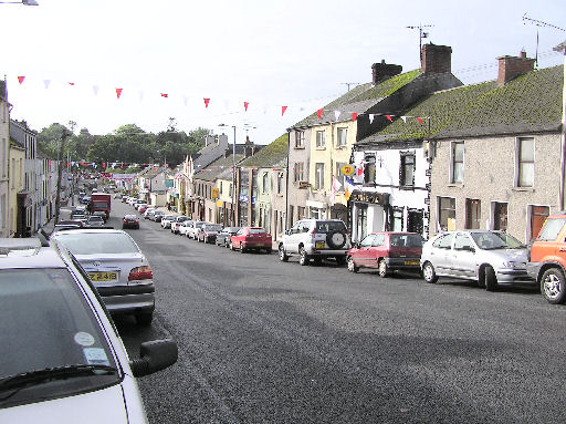
English: Ballygawley Co. Tyrone. Ballygawley is a small town located at the junction of two major roads, the A4 and A5, the Ballygawley roundabout is one the most frequented traffic routes in Ulster. This has been now been bypassed by the Ballygawley Roundabout 62150 Ballygawley was one of the first towns in Ireland to have its own electricity supply from a water turbine on the Ballygawley river. Nearby, the river Blackwater provides some good fishing.
|
| ⧼wm-license-information-date⧽ | 2005 |
| ⧼wm-license-information-source⧽ | From geograph.org.uk |
| ⧼wm-license-information-author⧽ | Kenneth Allen |
| ⧼wm-license-cc-attribution⧽ (قالب:I18n/Credit line) |
Kenneth Allen / Ballygawley Co. Tyrone / |
54°27′35″N 7°01′40″W / 54.45961°N 7.0277°W قالب:Object location
_heading:0)
ترخيص
تاريخ الملف
اضغط على زمن/تاريخ لرؤية الملف كما بدا في هذا الزمن.
| زمن/تاريخ | صورة مصغرة | الأبعاد | مستخدم | تعليق | |
|---|---|---|---|---|---|
| حالي | ★ مراجعة معتمدة 00:52، 12 نوفمبر 2023 | | 512 × 383 (71 كيلوبايت) | Pastakhov (نقاش | مساهمات) | Upload https://upload.wikimedia.org/wikipedia/commons/4/4d/Ballygawley_Co._Tyrone_-_geograph.org.uk_-_62151.jpg |
لا يمكنك استبدال هذا الملف.
وصلات
لا يوجد صفحات تصل لهذه الصورة.