ملف:Babylone 1-es.svg

حجم معاينة PNG لذلك الملف ذي الامتداد SVG: 800 × 568 بكسل. البعد الآخر: 2٬560 × 1٬819 بكسل.
الملف الأصلي (ملف SVG، أبعاده 1٬821 × 1٬294 بكسل، حجم الملف: 11٫9 ميجابايت)
وصف قصير
| ⧼wm-license-information-description⧽ |
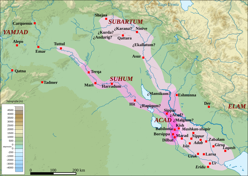
English: Map of the kingdom of the First Dynasty of Babylon from the beginning of the reign of Hammurabi (1792-1750 BC according to middle chronology) to the fall of Babylon in 1595 BC. The maximal extension of the kingdom under the reigns of Hammrabi and his son Samsu-iluna includes cities that have been taken by those kings, but probably dominated at best a few years, like Tuttul, Nineveh and Shekhna. The domination of Terqa by the successors of Samsu-iluna is probable because of some of them appear in the name years of tablets excavated there (Ammi-saduqa, Samsu-ditana).
Legend: Babylonian kingdom at the beginning of Hammurabi's reign (1792 BC)
Territories from Hammurabi to the late paleo-babylonian kings (1792-1595 BC)
Maximum extent under Hammurabi (1792-1750 BC) & Samsu-iluna (1750-1712 BC)
Kish: city whose location is known Malgium: city whose location is unsure/known Ur: city abandoned during the reign of Samsu-iluna (1750-1712 BC) |
| ⧼wm-license-information-date⧽ | 2019 |
| ⧼wm-license-information-source⧽ | قالب:Derived from |
| ⧼wm-license-information-author⧽ | Sémhur, Zunkir, rowanwindwhistler |
ترخيص
|
|
هذا الملفُّ مُرخَّص بموجب رخصة المشاع الإبداعي نسبة المُصنَّف إِلى مؤلفه - المشاركة بالمثل 3.0 العامة. |
تاريخ الملف
اضغط على زمن/تاريخ لرؤية الملف كما بدا في هذا الزمن.
| زمن/تاريخ | صورة مصغرة | الأبعاد | مستخدم | تعليق | |
|---|---|---|---|---|---|
| حالي | ★ مراجعة معتمدة 02:51، 20 أكتوبر 2023 | | 1٬821 × 1٬294 (11٫9 ميجابايت) | Pastakhov (نقاش | مساهمات) | Upload https://upload.wikimedia.org/wikipedia/commons/7/76/Babylone_1-es.svg |
لا يمكنك استبدال هذا الملف.
وصلات
لا يوجد صفحات تصل لهذه الصورة.