ملف:Austria satellite unannotated.jpg

الملف الأصلي (2٬550 × 1٬381 بكسل حجم الملف: 1٫05 ميجابايت، نوع MIME: image/jpeg)
| ⧼wm-license-information-description⧽ |
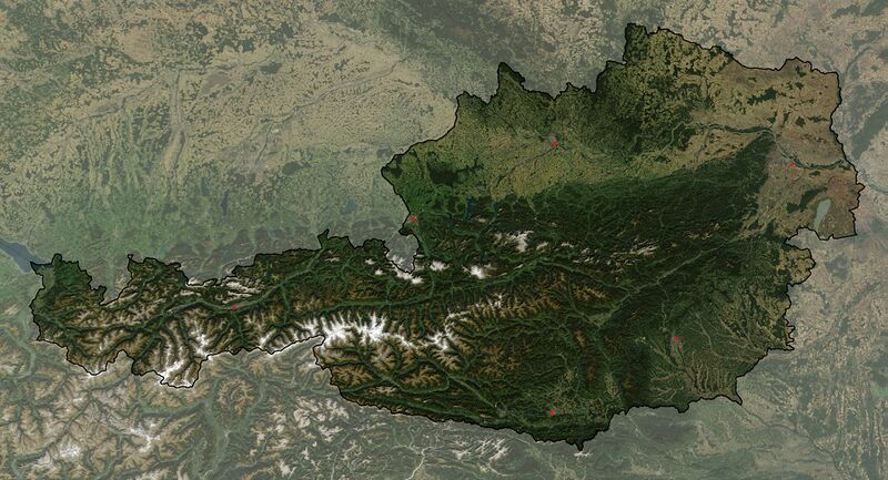
Satellite image of Austria with very few annotations |
| ⧼wm-license-information-date⧽ | 2005 |
| ⧼wm-license-information-source⧽ | The image is based on a satellite image from [1]. Original image: Credit Jeff Schmaltz, MODIS Rapid Response Team, NASA/GSFC. |
| ⧼wm-license-information-author⧽ | Michael Schmid |
| ⧼wm-license-information-permission⧽ (⧼wm-license-information-permission-reusing-text⧽) |
Based on a NASA image, thus in the public domain. |
| ⧼wm-license-information-other-versions⧽ |
Image:Austria_satellite_annotated.jpg with more annotations; Image:Austria satellite Grosslandschaften markerstyle.png with borders of large landscapes of Austria |
![[1]](http://visibleearth.nasa.gov/images/5947/Italy.A2003262.1005.250m.jpg)
I have cropped the image to show only Austria and its immediate surroundings, extracted the Austrian border (with much manual drawing required) and thickened the line, reduced the contrast of the area around Austria and stretched the image in y direction by about 5% to obtain the correct aspect ratio. I have improved the visibility of the city symbols of Wien (Vienna) and Linz and added symbols for Innsbruck, Graz, Klagenfurt and Salzburg. Please note: The positions of Wien (Vienna) and Linz were not very accurate in the original satellite image; this has been corrected in the annotated version of this map Image:Austria Satellite annotated.jpg.
تاريخ الملف
اضغط على زمن/تاريخ لرؤية الملف كما بدا في هذا الزمن.
| زمن/تاريخ | صورة مصغرة | الأبعاد | مستخدم | تعليق | |
|---|---|---|---|---|---|
| حالي | ★ مراجعة معتمدة 10:47، 16 يناير 2024 | | 2٬550 × 1٬381 (1٫05 ميجابايت) | Pastakhov (نقاش | مساهمات) | Upload https://upload.wikimedia.org/wikipedia/commons/7/71/Austria_satellite_unannotated.jpg |
لا يمكنك استبدال هذا الملف.
وصلات
لا يوجد صفحات تصل لهذه الصورة.