ملف:ArrTurnhoutLocatie.png
لا توجد دقة أعلى متوفرة.
ArrTurnhoutLocatie.png (270 × 203 بكسل حجم الملف: 2 كيلوبايت، نوع MIME: image/png)
وصف قصير
| ⧼wm-license-information-description⧽ |
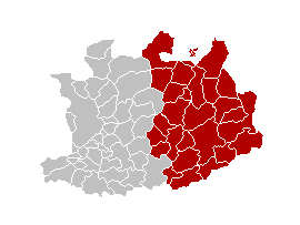
English: This map indicates (in red) the location of administrative and judicial arrondissements of Turnhout in the province of Antwerp, Belgium. Both maps are the same and fill all the province of Antwerp. In this case, a redirection is available at File:Judicial_Arrondissement_Turnhout_Belgium_Map.png for an easy and intuitive access to judicial arrondissement map.
Français : Cette carte indique (en rouge) la localisation de l'arrondissement administratif et judiciaire de Turnhout dans la Province d'Anvers, Belgique. Les deux cartes se confondent et occupent toute la province d'Anvers. De cette manière, une redirection est accessible à File:Judicial_Arrondissement_Turnhout_Belgium_Map.png pour un accès facile et intuitif à la carte de l'arrondissement judiciaire.
|
| ⧼wm-license-information-date⧽ | |
| ⧼wm-license-information-source⧽ | ⧼Wm-license-own-work⧽ |
| ⧼wm-license-information-author⧽ | w:nl:Gebruiker:Westermarck |
ترخيص

|
تاريخ الملف
اضغط على زمن/تاريخ لرؤية الملف كما بدا في هذا الزمن.
| زمن/تاريخ | صورة مصغرة | الأبعاد | مستخدم | تعليق | |
|---|---|---|---|---|---|
| حالي | ★ مراجعة معتمدة 23:31، 5 أكتوبر 2023 | | 270 × 203 (2 كيلوبايت) | Pastakhov (نقاش | مساهمات) | Upload https://upload.wikimedia.org/wikipedia/commons/8/88/ArrTurnhoutLocatie.png |
لا يمكنك استبدال هذا الملف.
وصلات
لا يوجد صفحات تصل لهذه الصورة.