ملف:Antarctic profile hg.png
حجم هذه المعاينة: 800 × 574 بكسل. البعد الآخر: 1٬078 × 774 بكسل.
الملف الأصلي (1٬078 × 774 بكسل حجم الملف: 191 كيلوبايت، نوع MIME: image/png)
| ⧼wm-license-information-description⧽ |
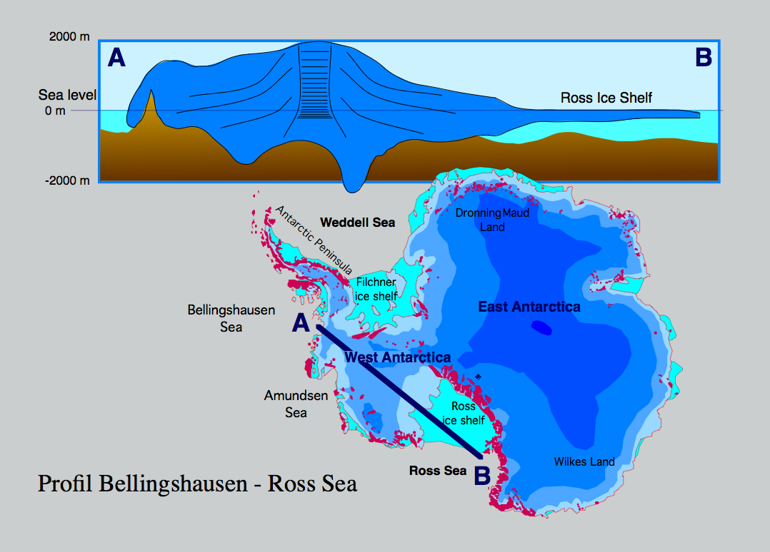
Profile through the Antarctic ice sheet (A) Bellingshausen Sea - West Antarctic ice sheet - Ross ice shelf - Ross Sea (B). The profile shows that most of the West Antarctic ice sheet is grounded below sea level which makes it sensitive to sea level rise. If the contact of the ice to the bottom rocks is lost seaward of the grounding line, the ice sheet becomes significantly thinner (some 100 m), forming a shelf ice.
|
| ⧼wm-license-information-date⧽ | 2006 |
| ⧼wm-license-information-source⧽ | ⧼Wm-license-own-work⧽ |
| ⧼wm-license-information-author⧽ | Hannes Grobe 21:51, 12 August 2006 (UTC), Alfred Wegener Institute for Polar and Marine Research, Bremerhaven, Germany |
| ⧼wm-license-information-permission⧽ (⧼wm-license-information-permission-reusing-text⧽) |
Own work, share alike, attribution required (Creative Commons CC-BY-SA-2.5) |
تاريخ الملف
اضغط على زمن/تاريخ لرؤية الملف كما بدا في هذا الزمن.
| زمن/تاريخ | صورة مصغرة | الأبعاد | مستخدم | تعليق | |
|---|---|---|---|---|---|
| حالي | ★ مراجعة معتمدة 09:40، 25 نوفمبر 2023 | | 1٬078 × 774 (191 كيلوبايت) | Pastakhov (نقاش | مساهمات) | Upload https://upload.wikimedia.org/wikipedia/commons/f/f2/Antarctic_profile_hg.png |
لا يمكنك استبدال هذا الملف.
وصلات
لا يوجد صفحات تصل لهذه الصورة.