ملف:Anishinaabe-Anishinini Distribution Map.svg

حجم معاينة PNG لذلك الملف ذي الامتداد SVG: 617 × 599 بكسل. البعد الآخر: 2٬108 × 2٬048 بكسل.
الملف الأصلي (ملف SVG، أبعاده 1٬022 × 993 بكسل، حجم الملف: 89 كيلوبايت)
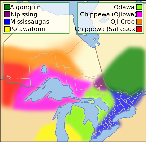
وصف قصير
| ⧼wm-license-information-description⧽ |
English: Anishinaabe and Anishinini distribution around 1800.
|
| ⧼wm-license-information-date⧽ | 2013, {{time}} – invalid date format 55 (help) |
| ⧼wm-license-information-source⧽ | ⧼Wm-license-own-work⧽ |
| ⧼wm-license-information-author⧽ | DarrenBaker |
ترخيص
|
تاريخ الملف
اضغط على زمن/تاريخ لرؤية الملف كما بدا في هذا الزمن.
| زمن/تاريخ | صورة مصغرة | الأبعاد | مستخدم | تعليق | |
|---|---|---|---|---|---|
| حالي | ★ مراجعة معتمدة 03:05، 15 نوفمبر 2023 | | 1٬022 × 993 (89 كيلوبايت) | Pastakhov (نقاش | مساهمات) | Upload https://upload.wikimedia.org/wikipedia/commons/a/a0/Anishinaabe-Anishinini_Distribution_Map.svg |
لا يمكنك استبدال هذا الملف.
وصلات
لا يوجد صفحات تصل لهذه الصورة.
معلومات الصورة (ميتا)
تصنيفات:
- Self-published work
- Ojibwe maps
- Anishinaabe
- Maps of Ontario
- Maps of Native American tribal territories
- History of indigenous peoples of the Great Lakes Region
- First Nations in Ontario
- First Nations in Quebec
- Native American history of Minnesota
- Native American history of Michigan
- Native American history of Wisconsin
- Odawa
- Mississaugas
- Potawatomi
- Algonquin maps
- Nipissing First Nation