ملف:Alptransit project overview engl.jpg

حجم هذه المعاينة: 800 × 546 بكسل. البعد الآخر: 1٬000 × 682 بكسل.
الملف الأصلي (1٬000 × 682 بكسل حجم الملف: 239 كيلوبايت، نوع MIME: image/jpeg)
وصف قصير
| ⧼wm-license-information-description⧽ |
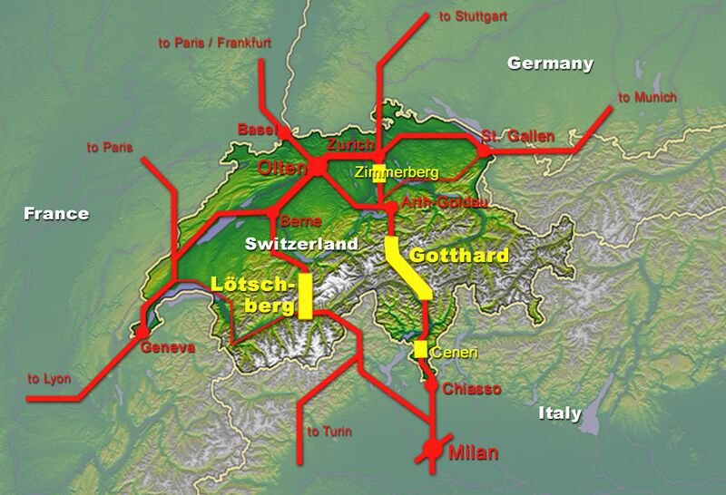
English: Overview of the New Railway Link through the Alps NRLA / Alptransit project in Switzerland with all planned base tunnels and connections to the European rail network
(yellow: base tunnels, red: existing main rail links) Italiano: Vista generale del nuovo collegamento ferroviario attraverso le alpi in Svizzera con tutti tunnel di base pianificati e le connessioni alla rete ferroviaria europea. In giallo sono indicati i tunnel di base e in rosso i collegamenti principali esistenti
|
| ⧼wm-license-information-date⧽ | 2006 |
| ⧼wm-license-information-source⧽ | topomap: Image:Alpenrelief 02.jpg / overlay drawing by: Cooper.ch |
| ⧼wm-license-information-author⧽ | --Cooper.ch 19:59, 13 August 2006 (UTC) |
| ⧼wm-license-information-permission⧽ (⧼wm-license-information-permission-reusing-text⧽) |
topomap has CCA ShareAlike 2.5 license, since no downgrade is possible, I hereby release my overlay graphic under the same license |
| ⧼wm-license-information-other-versions⧽ |
Original german version on de.wikipedia.org, named Bild:NEAT im europ Eisenbahnnetz.jpg |
ترخيص
قالب:Cc-by-sa-3.0-migrated |

تاريخ الملف
اضغط على زمن/تاريخ لرؤية الملف كما بدا في هذا الزمن.
| زمن/تاريخ | صورة مصغرة | الأبعاد | مستخدم | تعليق | |
|---|---|---|---|---|---|
| حالي | ★ مراجعة معتمدة 16:00، 25 ديسمبر 2023 | | 1٬000 × 682 (239 كيلوبايت) | Pastakhov (نقاش | مساهمات) | Upload https://upload.wikimedia.org/wikipedia/commons/d/d5/Alptransit_project_overview_engl.jpg |
لا يمكنك استبدال هذا الملف.
وصلات
لا يوجد صفحات تصل لهذه الصورة.