ملف:Alert, Canada ESA375402.jpg
الملف الأصلي (4٬620 × 3٬591 بكسل حجم الملف: 28٫05 ميجابايت، نوع MIME: image/jpeg)
وصف قصير
| ⧼wm-license-information-description⧽ |
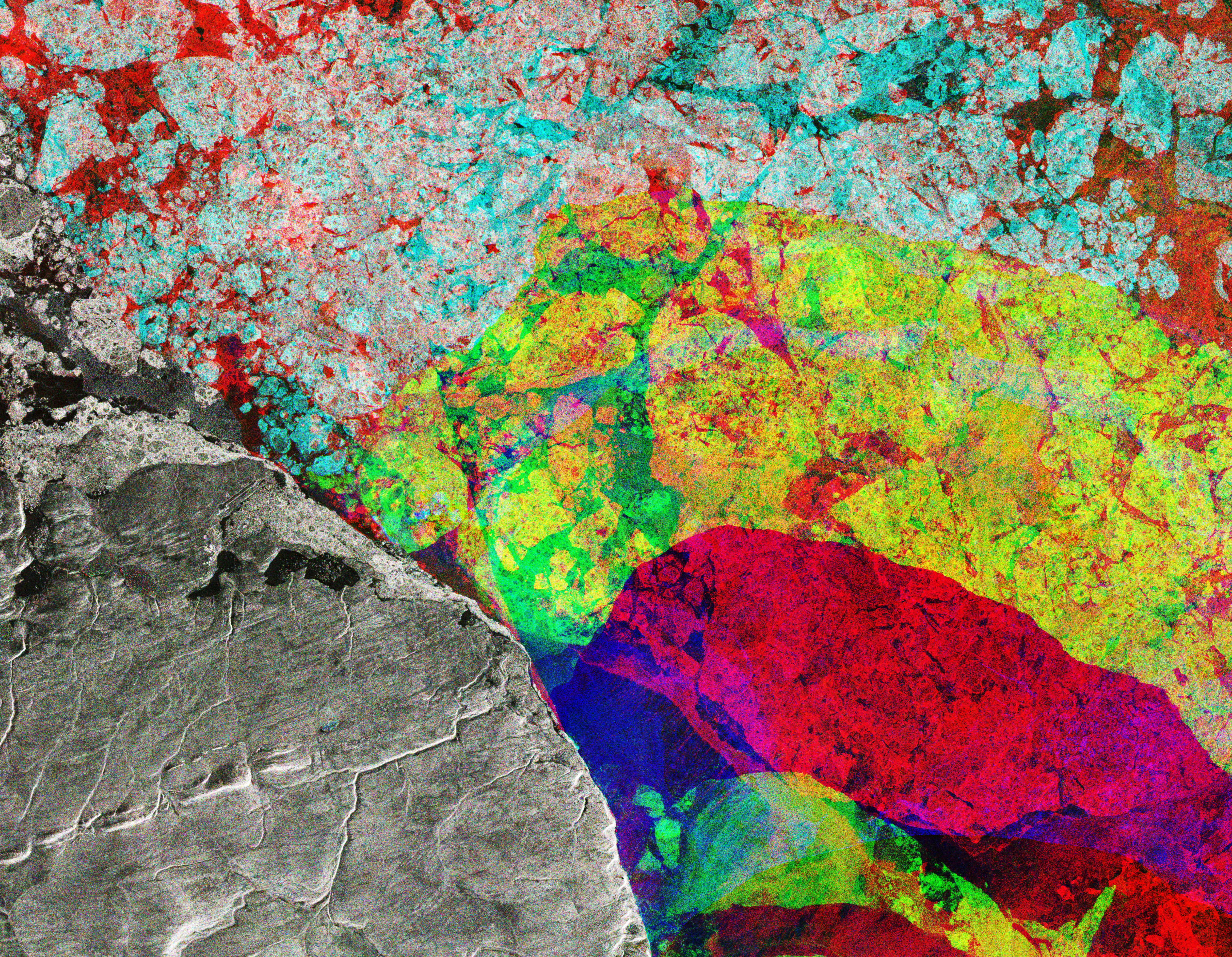
English: This Sentinel-1 radar composite image takes us to the northeastern tip of Ellesmere Island (lower-left), where the Nares Strait opens up into the Lincoln Sea in the Canadian Arctic.
The image was created by combining three radar scans from Copernicus Sentinel-1 captured in December, January and February. Each image has been assigned a colour – red, green and blue – and create this colourful composite when combined. Colours show changes between acquisitions, such as the movement of ice in the Lincoln Sea, while the static landmass is grey. The obvious distinction between the red and yellow depicts how the ice cover has changed over the three months. The maximum extent of Arctic sea ice hit a record low this winter. Scientists attribute the reduced ice cover to a very warm autumn and winter, exacerbated by a number of extreme winter ‘heat waves’ over the Arctic Ocean. In the centre-left on the land, we can see a straight, dark link with a circle at its left end. This is the runway for Alert – the northernmost known settlement in the world. Inhabited mainly by military and scientific personnel on rotation, Alert is about 800 km from the North Pole. A team of researchers on the CryoVex/Karen campaign was recently in Alert validating sea-ice thickness measurements from the CryoSat satellite and testing future satellite mission concepts. Taking off from Alert, the team flew two aircraft equipped with instruments that measure sea-ice thickness at the same time the satellite flew some 700 km overhead. The measurements from the airborne campaign will be compared to the satellite measurements in order to confirm the satellite’s accuracy. A team will also make ground measurements of snow and ice along a CryoSat ground track in April. Ground campaigns like this provide a wealth of data that help scientists better understand how the Arctic is changing and, ultimately, how climate is changing. This image is featured on the Earth from Space video programme.Français : Image radar composite, satellite Sentinel-1 : pointe nord-est de l'île d'Ellesmere (en bas à gauche), où le détroit de Nares s'ouvre sur la mer de Lincoln dans l'Arctique canadien. L'image combine trois balayages radar de Copernicus Sentinel-1 capturés en décembre, janvier et février, respectivement rouge, vert et bleu ; créant un composite coloré quand il est combiné. Les couleurs montrent les changements entre les acquisitions, comme le mouvement de la glace dans la mer de Lincoln, tandis que la masse terrestre statique est grise. La distinction évidente entre le rouge et le jaune montre comment la couverture de glace a changé au cours des trois mois. L'étendue maximale de la banquise arctique a atteint un niveau record cet hiver. Les scientifiques attribuent la réduction de la couverture de glace à un automne et un hiver très chauds, exacerbés par un certain nombre de « vagues de chaleur » hivernales extrêmes sur l'océan Arctique. Au centre-gauche sur le terrain, on peut voir un lien droit et sombre avec un cercle à son extrémité gauche ; c'est la piste d'atterrissage d'Alert (colonie la plus septentrionale du monde, habitée principalement par des militaires et scientifiques en rotation, à environ 800 km du pôle Nord. Une équipe de chercheurs de la campagne CryoVex/Karen était récemment à Alert pour valider les mesures d'épaisseur de glace de mer du satellite CryoSat et tester les futurs concepts de mission satellitaire. Décollant d'Alert, l'équipe a piloté deux avions équipés d'instruments qui mesurent l'épaisseur de la glace de mer en même temps que le satellite survolait quelque 700 km au-dessus de sa tête. Les mesures de la campagne aéroportée seront comparées aux mesures satellitaires afin de confirmer la précision du satellite. Une équipe effectuera également des mesures au sol de la neige et de la glace le long d'une piste au sol CryoSat en avril. Des campagnes au sol comme celle-ci fournissent une mine de données qui aident les scientifiques à mieux comprendre comment l'Arctique change et, en fin de compte, comment le climat change.
|
| ⧼wm-license-information-date⧽ | 2017 |
| ⧼wm-license-information-source⧽ | http://www.esa.int/spaceinimages/Images/2017/03/Alert_Canada |
| ⧼wm-license-information-author⧽ | European Space Agency |
| ⧼wm-license-information-permission⧽ (⧼wm-license-information-permission-reusing-text⧽) |
contains modified Copernicus Sentinel data (2016-17), processed by ESA,CC BY-SA 3.0 IGO |
| ⧼wm-license-information-other-versions⧽ |
|
| Title | Alert, Canada |
| Set | Earth observation image of the week |
| System | Copernicus |
| Mission | Sentinel-1 |
| Location | Canada |
| Activity | Observing the Earth |
| Keywords | Ice |
ترخيص
تاريخ الملف
اضغط على زمن/تاريخ لرؤية الملف كما بدا في هذا الزمن.
| زمن/تاريخ | صورة مصغرة | الأبعاد | مستخدم | تعليق | |
|---|---|---|---|---|---|
| حالي | ★ مراجعة معتمدة 16:30، 30 نوفمبر 2023 | | 4٬620 × 3٬591 (28٫05 ميجابايت) | Pastakhov (نقاش | مساهمات) | Upload https://upload.wikimedia.org/wikipedia/commons/b/be/Alert%2C_Canada_ESA375402.jpg |
لا يمكنك استبدال هذا الملف.
وصلات
لا يوجد صفحات تصل لهذه الصورة.