ملف:Akitanieraren aztarna geografikoak.svg

حجم معاينة PNG لذلك الملف ذي الامتداد SVG: 617 × 468 بكسل. البعد الآخر: 2٬560 × 1٬942 بكسل.
الملف الأصلي (ملف SVG، أبعاده 617 × 468 بكسل، حجم الملف: 208 كيلوبايت)
وصف قصير
| ⧼wm-license-information-description⧽ |
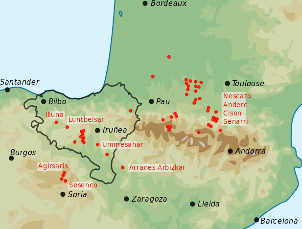
Euskara: Akitanieraren aztarna geografikoak; puntu gorriek adierazten dute akitanierazko izenak aurkitu diren tokiak
English: Geographical traces of the Aquitanian language (predecessor of modern Basque). Red dots are locations where aquitanian names have been discovered.
|
| ⧼wm-license-information-date⧽ | 2019 |
| ⧼wm-license-information-source⧽ | ⧼Wm-license-own-work⧽ |
| ⧼wm-license-information-author⧽ | Assar, based on Gorrochategui, Historia de la lengua vasca, p. 269 |
ترخيص
|
تاريخ الملف
اضغط على زمن/تاريخ لرؤية الملف كما بدا في هذا الزمن.
| زمن/تاريخ | صورة مصغرة | الأبعاد | مستخدم | تعليق | |
|---|---|---|---|---|---|
| حالي | ★ مراجعة معتمدة 16:01، 2 نوفمبر 2023 | | 617 × 468 (208 كيلوبايت) | Pastakhov (نقاش | مساهمات) | Upload https://upload.wikimedia.org/wikipedia/commons/5/58/Akitanieraren_aztarna_geografikoak.svg |
لا يمكنك استبدال هذا الملف.
وصلات
لا يوجد صفحات تصل لهذه الصورة.