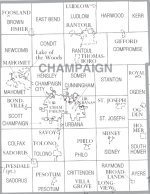
مقاطعة شامپين، إلينوي
| ||||||||||||||||||||||||||||||||||||||||||||
| ||||||||||||||||||||||||||||||||||||||||||||
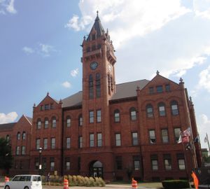
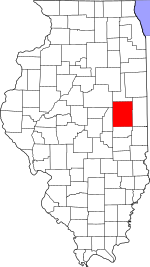
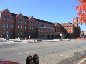
مقاطعة شامپين إنگليزية: Champaign County هي إحدى المقاطعات في ولاية إلينوي في الولايات المتحدة. As of the 2020 Census, its population was 205,865,[1] making it the 10th-most populous county in Illinois. Its county seat is Urbana.[2]
Champaign County is part of the Champaign–Urbana metropolitan area. The twin cities of Urbana and Champaign are the only cities in the county, and they nearly surround the campus of the University of Illinois.
. . . . . . . . . . . . . . . . . . . . . . . . . . . . . . . . . . . . . . . . . . . . . . . . . . . . . . . . . . . . . . . . . . . . . . . . . . . . . . . . . . . . . . . . . . . . . . . . . . . . . . . . . . . . . . . . . . . . . . . . . . . . . . . . . . . . . . . . . . . . . . . . . . . . . . . . . . . . . . . . . . . . . . . .
التاريخ
Champaign County was organized in 1833, having been previously a part of Vermilion County.[3] The development of the county was greatly furthered by the arrival of the Chicago Branch of the Illinois Central Railroad, and even more by the establishment of the land-grant university. Later, the county also got an airport and a mass transit district. The northern part of the county experienced an economic and demographic setback with the closing of Chanute Air Force Base in the 1990s. In the 2004 Presidential election, it was one of only 15 of the 102 Illinois counties where John Kerry received a majority of the vote (50.37%).[4]
الجغرافيا
The county is 27 miles wide (east–west) and 36 miles long (north–south).[5] Its area is 998 square miles (2,580 km2), of which 996 square miles (2,580 km2) is land and 2.1 square miles (5.4 km2) (0.2%) is water.[6] It is the fifth-largest county in Illinois by land area.
Because Champaign County is situated on a large and very flat plateau, it had virtually no natural drainage, so that much of the County consisted of wetlands until drainage ditches were built, beginning in the 1870s. This was an example of an upland marsh, which resulted in a high incidence of malaria before the late nineteenth century.
The topography of Champaign County was formed by the Wisconsin glaciation about 20,000 years before the present. Lobes of ice from what is now Lake Michigan crossed the county, creating a deep pile of glacial soil, up to 300 feet thick, topped by numerous moraines forming small, flat watersheds with no outlets.
Champaign County is situated on the divide between the Ohio and Mississippi Rivers. Rivers flow out of Champaign County to the east, west, and south. The Kaskaskia River has its origin to the northwest of Champaign, draining the western side of that City. The Kaskaskia flows toward the southwest, joining the Mississippi south of St. Louis, Missouri.
The Embarras River, on the other hand, drains the south-central portion of Champaign–Urbana, originating in southeastern Champaign and flowing through the experimental fields on the southern part of the campus of the University of Illinois. The Embarras [ك] is a tributary to the Wabash River and Ohio River systems. The northeast corner of Champaign, the central portion of the University campus, and the northern part of Urbana are drained by the Boneyard Creek, which flows into the Saline Branch, a tributary of the Vermilion and Wabash rivers.
المقاطعات المجاورة
- Ford County - north
- Vermilion County - east
- Edgar County - southeast
- Douglas County - south
- Piatt County - west
- McLean County - northwest
المناخ
| إربانا، إلينوي | ||||||||||||||||||||||||||||||||||||||||||||||||||||||||||||
|---|---|---|---|---|---|---|---|---|---|---|---|---|---|---|---|---|---|---|---|---|---|---|---|---|---|---|---|---|---|---|---|---|---|---|---|---|---|---|---|---|---|---|---|---|---|---|---|---|---|---|---|---|---|---|---|---|---|---|---|---|
| جدول الطقس (التفسير) | ||||||||||||||||||||||||||||||||||||||||||||||||||||||||||||
| ||||||||||||||||||||||||||||||||||||||||||||||||||||||||||||
| ||||||||||||||||||||||||||||||||||||||||||||||||||||||||||||
. . . . . . . . . . . . . . . . . . . . . . . . . . . . . . . . . . . . . . . . . . . . . . . . . . . . . . . . . . . . . . . . . . . . . . . . . . . . . . . . . . . . . . . . . . . . . . . . . . . . . . . . . . . . . . . . . . . . . . . . . . . . . . . . . . . . . . . . . . . . . . . . . . . . . . . . . . . . . . . . . . . . . . . .
السكان
| التعداد التاريخي | |||
|---|---|---|---|
| التعداد | Pop. | %± | |
| 1840 | 1٬475 | — | |
| 1850 | 2٬649 | 79٫6% | |
| 1860 | 14٬629 | 452٫2% | |
| 1870 | 32٬737 | 123٫8% | |
| 1880 | 40٬863 | 24٫8% | |
| 1890 | 42٬159 | 3٫2% | |
| 1900 | 47٬622 | 13�0% | |
| 1910 | 51٬829 | 8٫8% | |
| 1920 | 56٬959 | 9٫9% | |
| 1930 | 64٬273 | 12٫8% | |
| 1940 | 70٬578 | 9٫8% | |
| 1950 | 106٬100 | 50٫3% | |
| 1960 | 132٬436 | 24٫8% | |
| 1970 | 163٬281 | 23٫3% | |
| 1980 | 168٬392 | 3٫1% | |
| 1990 | 173٬025 | 2٫8% | |
| 2000 | 179٬669 | 3٫8% | |
| 2010 | 201٬081 | 11٫9% | |
| 2013 (تق.) | 204٬897 | 1٫9% | |
التجمعات السكنية
المدن
القرى
البلدات
Unincorporated communities
انظر أيضاً
الهامش
- ^ أ ب "Census - Geography Profile: Champaign County, Illinois". United States Census Bureau. Retrieved October 5, 2021.
- ^ "Find a County". National Association of Counties. Archived from the original on May 31, 2011. Retrieved June 7, 2011.
- ^ "John W. Vance: The "Father of Champaign County" | Urbana Free Library". urbanafreelibrary.org. Retrieved February 9, 2022.
- ^ Leip, David. "Dave Leip's Atlas of U.S. Presidential Elections – 2004 Presidential General Election Results – Champaign County, Illinois". uselectionatlas.org. Retrieved April 18, 2018.
- ^ Hopkins, Cyril G.; Mosier, J. G.; van Alstine, E.; Garrett, P. W. (1918). Champaign County soils. University of Illinois Agricultural Experiment Station. p. 1.
- ^ خطأ استشهاد: وسم
<ref>غير صحيح؛ لا نص تم توفيره للمراجع المسماةcensus-density - ^ "Monthly Averages for Urbana, Illinois". The Weather Channel. Retrieved 2011-01-27.
- ^ "U.S. Decennial Census". United States Census Bureau. Retrieved July 4, 2014.
- ^ "Historical Census Browser". University of Virginia Library. Retrieved July 4, 2014.
- ^ "Population of Counties by Decennial Census: 1900 to 1990". United States Census Bureau. Retrieved July 4, 2014.
- ^ "Census 2000 PHC-T-4. Ranking Tables for Counties: 1990 and 2000" (PDF). United States Census Bureau. Retrieved July 4, 2014.
ببليوگرافيا
- Mathews, Milton W; McLean, Lewis A. (1886). Early History and Pioneers of Champaign County. Urbana, Illinois: Champaign County Herald. Retrieved 2010-11-29.
- Stewart, J. R., ed. (1918). A Standard History of Champaign County Illinois. Vol. 1. Chicago and New York: The Lewis Publishing Company. Retrieved 2010-11-29.
- Stewart, J. R., ed. (1918). A Standard History of Champaign County Illinois. Vol. 2. Chicago and New York: The Lewis Publishing Company. Retrieved 2010-11-29.
- Cunningham, Joseph O., ed. (1905). Historical Encyclopedia of Illinois and History of Champaign County. Chicago: Munsell Publishing Company. pp. 631–1060. Retrieved 2010-11-29.
. . . . . . . . . . . . . . . . . . . . . . . . . . . . . . . . . . . . . . . . . . . . . . . . . . . . . . . . . . . . . . . . . . . . . . . . . . . . . . . . . . . . . . . . . . . . . . . . . . . . . . . . . . . . . . . . . . . . . . . . . . . . . . . . . . . . . . . . . . . . . . . . . . . . . . . . . . . . . . . . . . . . . . . .
وصلات خارجية
- Champaign County Official Page
- United States Census Bureau 2007 TIGER/Line Shapefiles
- United States Board on Geographic Names (GNIS)
- United States National Atlas
- Book of the Champaign County Courthouse dedication from 1901
- Champaign Democrat, Google news archive. —PDFs of 1,286 issues, dating from 1887 through 1916.

|
Ford County | McLean County | 
| |
| Vermilion County | Piatt County | |||
| Edgar County | Douglas County |
- Pages using gadget WikiMiniAtlas
- Short description is different from Wikidata
- مقاطعات Illinois
- Pages using infobox U.S. county with unknown parameters
- Articles containing إنگليزية-language text
- Pages using Lang-xx templates
- Pages using US Census population needing update
- Pages using div col with unknown parameters
- Portal-inline template with redlinked portals
- Pages with empty portal template
- Coordinates on Wikidata
- Illinois counties
- 1833 establishments in Illinois
- Populated places established in 1833
- Champaign County, Illinois
- مقاطعات ولاية إلينوي الأمريكية
