دوڤر
(تم التحويل من دوفر)
| Dover | |
|---|---|
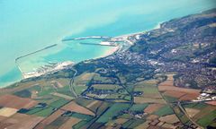
 Aerial view of Dover Harbour | |
Location within Kent | |
| Population | 31٬022 (2011 Census)[1] |
| OS grid reference | TR315415 |
| • London | 77.8 miles (125.2 km) |
| Civil parish |
|
| District | |
| Shire county | |
| Region | |
| Country | England |
| Sovereign state | United Kingdom |
| Post town | DOVER |
| Postcode district | CT16, CT17 |
| Dialling code | 01304 |
| Police | Kent |
| Fire | Kent |
| Ambulance | South East Coast |
| EU Parliament | South East England |
| UK Parliament | |
دوڤر (Dover ؛ /ˈdoʊvər/) هي مدينة تقع في جنوب شرق إنجلترا. يبلغ عدد سكانها حوالي 28,000 نسمة (2001).
| Climate data for مرفأ دوڤر (الشاطئ)، الارتفاع: 0م (1981-2010) | |||||||||||||
|---|---|---|---|---|---|---|---|---|---|---|---|---|---|
| Month | Jan | Feb | Mar | Apr | May | Jun | Jul | Aug | Sep | Oct | Nov | Dec | Year |
| Record high °C (°F) | 16 (61) |
13 (55) |
18 (64) |
23 (73) |
26 (79) |
28 (82) |
31 (88) |
31 (88) |
25 (77) |
24 (75) |
16 (61) |
14 (57) |
31 (88) |
| Mean daily maximum °C (°F) | 7.8 (46.0) |
7.8 (46.0) |
10.1 (50.2) |
11.9 (53.4) |
15.7 (60.3) |
18.2 (64.8) |
20.7 (69.3) |
21.1 (70.0) |
18.8 (65.8) |
15.4 (59.7) |
11.4 (52.5) |
8.4 (47.1) |
14.0 (57.2) |
| Daily mean °C (°F) | 5.6 (42.1) |
5.4 (41.7) |
7.4 (45.3) |
9.1 (48.4) |
12.5 (54.5) |
15.2 (59.4) |
17.5 (63.5) |
17.8 (64.0) |
15.8 (60.4) |
12.6 (54.7) |
8.9 (48.0) |
6.2 (43.2) |
11.2 (52.2) |
| Mean daily minimum °C (°F) | 3.3 (37.9) |
3.0 (37.4) |
4.6 (40.3) |
6.3 (43.3) |
9.3 (48.7) |
12.1 (53.8) |
14.3 (57.7) |
14.5 (58.1) |
12.8 (55.0) |
9.8 (49.6) |
6.4 (43.5) |
4.0 (39.2) |
8.4 (47.1) |
| Record low °C (°F) | −5 (23) |
−8 (18) |
−4 (25) |
−1 (30) |
1 (34) |
5 (41) |
6 (43) |
8 (46) |
6 (43) |
1 (34) |
−3 (27) |
−6 (21) |
−8 (18) |
| Average precipitation mm (inches) | 74.9 (2.95) |
59.4 (2.34) |
51.5 (2.03) |
60.0 (2.36) |
50.9 (2.00) |
56.2 (2.21) |
49.5 (1.95) |
57.6 (2.27) |
67.4 (2.65) |
101.9 (4.01) |
102.2 (4.02) |
85.3 (3.36) |
816.8 (32.16) |
| Average precipitation days (≥ 1.0 mm) | 12.3 | 10.6 | 10.6 | 10.5 | 8.1 | 8.2 | 8.2 | 8.0 | 10.2 | 11.6 | 12.6 | 12.7 | 123.5 |
| Average relative humidity (%) | 88 | 86 | 84 | 81 | 83 | 84 | 84 | 82 | 82 | 84 | 87 | 88 | 84 |
| Mean monthly sunshine hours | 66.0 | 83.4 | 117.5 | 185.2 | 214.7 | 213.3 | 221.6 | 223.4 | 159.4 | 126.0 | 76.7 | 55.8 | 1٬743 |
| Source 1: Met Office[3] | |||||||||||||
| Source 2: weather2[4] | |||||||||||||
انظر أيضاً
الهامش
- ^ "Town population 2011". Retrieved 3 October 2015.
- ^ "Dover Town Council". dovertowncouncil.gov.uk.
- ^ "Dover 1981–2010 averages". Met Office. Retrieved 4 November 2012.
- ^ "Dover climate". weather2. Retrieved 8 November 2011.
ببليوگرافيا
- Statham, S.P.H. (1899). The history of the castle, town, and port of Dover. London: Longmans Green & Co. pp. 462 p.
- Foot, William (2006). Beaches, fields, streets, and hills ...: the anti-invasion landscapes of England, 1940. CBA research report 144. York: Council for British Archaeology. ISBN 1-902771-53-2.
وصلات خارجية
- UKHO nautical charts of Dover and approaches
- Dover Street Map
- The Dover War Memorial Project
- Western Heights Preservation Society
- Friends of Dover Castle A scheme for the local people of Dover to contribute and benefit from their Castle.
 "Dover. A Parliamentary and municipal borough of Kent, England". New International Encyclopedia. {{{year}}}.
تصنيفات:
- Pages using gadget WikiMiniAtlas
- Articles with OS grid coordinates
- Coordinates on Wikidata
- Dover, Kent
- Towns in Kent
- Cinque ports
- Populated coastal places in Kent
- Dover District
- Market towns in Kent
- France–United Kingdom border crossings
- Beaches of Kent
- Civil parishes in Kent
- Port cities and towns in South East England
- مدن إنگلترة
