سد توقتگول
| سد توقتگول | |
|---|---|
 السد الكهرمائي يغذيه خزان توقتگول | |
| الموقع | توقتگول |
| الإحداثيات | 41°39′25″N 72°38′10″E / 41.65707°N 72.63611°E |
| بدء الإنشاءات | 1960 |
| تاريخ الافتتاح | 1976 |
| السد والمفايض | |
| يحجز | نهر نارين |
| الارتفاع | 215 متر |
| الطول | 292.5 متر |
| سعة المفيض | 245 m3/s (8,700 cu ft/s) |
| الخزان | |
| يخلق | Toktogul Reservoir |
| السعة الإجمالية | 19.5 km3 (15,800,000 acre⋅ft) |
| السعة الفعالة | 14 km3 (11,000,000 acre⋅ft) |
| المساحة السطحية | 284.3 كم² |
| أقصى طول | 65 كم |
| أقصى عمق للماء | 120 متر |
| محطة الطاقة | |
| تاريخ الترخيص | 1978 |
| التوربينات | 4 X 300 MW |
| القدرة المركـّبة | 1,200 MW |
| السنوي | 4,400 GWh |
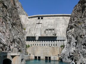
سد توقتگول Toktogul Dam هو سد لتوليد الكهرباء والري على نهر نارين في محافظة جلال آباد في قيرغيزستان. وهو سد تثاقلي خرساني ارتفاعه 215 متر وطوله 292.5 متر.[1] وهو جزء من تتابع نارين-سيحون. وهو مسمى على اسم توقتگول ساتيلگانوڤ.
محطة توقتگول الكهرمائية لديها قدرة توليد 1,200 ميگاواط، التي تجعله أكبر محطة توليد كهرباء في البلد. ويضم أربع توربينات بقدرة 300 MW لكل منهم.
خزان توقتگول (قرغيزية: Токтогул суу сактагычы، أصد: [toqtoʁul suː sɑqtɑʁɯtʃɯ]؛ روسية: Токтогульское водохранилище) هو أكبر الخزانات على مساء نهر نارين، الرافد الشمالي لنهر سيحون.[2] الخزان له سعة إجمالية 19.5 كم³، منها 14 كم³ سعة فعالة. وطوله 65 كم ومساحته السطحية هي 284.3 كم². أقصى عمق للخزان هو 120 متر.
مدينة قرةقل، جنوب الخزان (أسفل السد) آوت عمال إنشاء السد، وحالياً هي مقر طاقم تشغيل محطة توليد الكهرباء. مدينة توقتگول تقع شمال الخزان.
. . . . . . . . . . . . . . . . . . . . . . . . . . . . . . . . . . . . . . . . . . . . . . . . . . . . . . . . . . . . . . . . . . . . . . . . . . . . . . . . . . . . . . . . . . . . . . . . . . . . . . . . . . . . . . . . . . . . . . . . . . . . . . . . . . . . . . . . . . . . . . . . . . . . . . . . . . . . . . . . . . . . . . . .
الوقع البيئي والاجتماعي
The reservoir was created in 1976 after construction works on the dam were completed and the Kementub Valley was flooded. The reservoir flooded more than 26 thousand hectares of land, of which 21.2 thousand hectares of agricultural land, 26 communities including large settlement Toktogul were displaced and the main road through the region was re-routed.[3] Archaeologists excavated barrows from Saka times before the sites were lost.[4]
أزمة 2009
Toktogul Reservoir had a critically low water level in 2009. A cold dry winter, combined with water sales to foreign countries as well as increased domestic demand left the reservoir at a fraction of its capacity. Electrical rationing had to be employed throughout the entire country with outages lasting up to 11 hours every day.[بحاجة لمصدر]
المراجع
- ^ "List of major hydroelectric facilities Kyrgyzskoy Republic" (PDF) (in الروسية). CA Water. Retrieved 24 February 2012.
- ^ Irrigation in the countries of the former Soviet Union in figures. FAO. 1997. p. 128. ISBN 978-92-5-104071-3.
- ^ Shiriyazdanov, Sh. (1971). Токтогульский гигант строиться: очерк истории строительства ГЭС [Toktogul giant is being constructed: historical sketch of power plant construction] (in الروسية). Frunze: Ilim. p. 445.
- ^ "Toktogul travel guide". Caravanistan (in الإنجليزية الأمريكية). Retrieved 2020-05-11.
- Pages using gadget WikiMiniAtlas
- CS1 الروسية-language sources (ru)
- CS1 uses الروسية-language script (ru)
- CS1 الإنجليزية الأمريكية-language sources (en-us)
- Coordinates on Wikidata
- Articles containing Kyrgyz-language text
- Articles containing روسية-language text
- Pages using Lang-xx templates
- Articles with unsourced statements from October 2010
- سدود قيرغيزستان
- Hydroelectric power stations in Kyrgyzstan
- Hydroelectric power stations built in the Soviet Union
- سدود اكتملت في 1974
- سدود على نهر نارين
- سدود تثاقلية
- بنية تحتية للطاقة اكتملت في 1978
