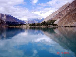
بحيرة عطا آباد
| بحيرة گوجال هنزة[1] | |
|---|---|
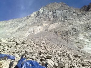
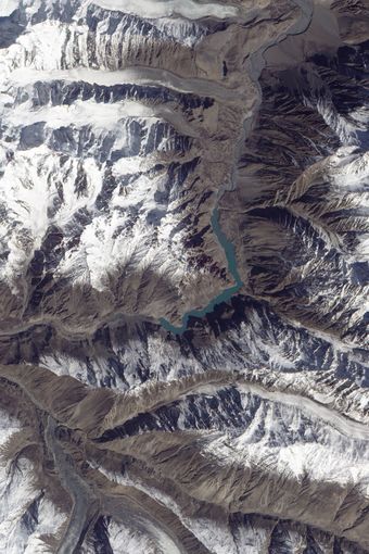 البحيرة شكـَّلها انزلاق أرضي في يناير 2010 | |
| الموقع | وادي گوجال، هنزة، پاكستان |
| الاحداثيات | Coordinates: 36°20′12.62″N 74°52′3.12″E / 36.3368389°N 74.8675333°E |
| الموارد الرئيسية | نهر هنزة، 2,800 cu ft/s (79 m3/s), 26 May 2010[2] |
| التصريفات الرئيسية | نهر هنزة overflowing landslide dam, 3,700 cu ft/s (100 m3/s), 4 June 2010 |
| بلدان الحوض | پاكستان |
| أقصى طول | 13 miles (21 km) |
| أقصى عمق | 358 feet (109 m)[3] |
| حجم المياه | 330,000 acre-feet (410,000,000 m3), 26 May 2010[2] |
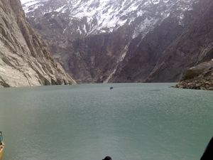
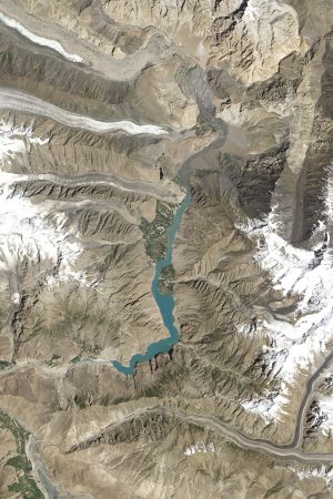
بحيرة عطا آباد، وادي گوجال، وتُعرف أيضاً بإسم بحيرة گوجال[4]، هي بحيرة في وادي گوجال في شمال پاكستان تكونت في يناير 2010 من سد انهيار أرضي.
تشكلت البحيرة بسبب انهيار أرضي هائل في قرية عطا آباد في گلگت-بلتستان، على بعد 14 كم أعلى (شرق) كريم آباد الذي حدث في 4 يناير 2010.[5] الانهيار قتل عشرين شخصاً وأعاق مجرى نهر هنزة لخمسة أشهر. تكون البحيرة تسبب في نزوح 6,000 شخص من القرى أعلى النهر، بالاضافة إلى 25,000 شخص انعزلوا (عن طرق المواصلات البرية)،[6] وغمرت ما يزيد عن 19 كم من طريق قرة قرم.[2] بلغ طول البحيرة 21 كم، وما يزيد عن 100 متر عمقاً، بحلول أول أسبوع في يونيو 2010 حين بدأت في الجريان فوق سد الانهيار الأرضي، مما غمر بالكامل قرية "شيشكات" وجزئياً گولميت.[2] تحصيل گوجال شهد أكبر عدد من المباني المُغرَقة، وهو ما يزيد عن 170 بيتاً، و 120 حانوتاً. كما عانى الأهالي من نقص المؤن بسبب انقطاع طريق قرة قرم.[7][8] وبحلول 4 يونيو ازداد مفيض المياه من البحيرة ليبلغ 3,700 cu ft/s (100 m3/s).[9]
Water levels continued to rise in June 18, 2010 caused by a difference in the the outflow and inflow of the new lake. As bad weather continued, the supply of food, medicine and other goods was stopped as all forms of transportation including helicopter service to Hunza could not resume.[10]
. . . . . . . . . . . . . . . . . . . . . . . . . . . . . . . . . . . . . . . . . . . . . . . . . . . . . . . . . . . . . . . . . . . . . . . . . . . . . . . . . . . . . . . . . . . . . . . . . . . . . . . . . . . . . . . . . . . . . . . . . . . . . . . . . . . . . . . . . . . . . . . . . . . . . . . . . . . . . . . . . . . . . . . .
أعقاب الإنزلاق
Victims of the landslide and expansion of the lake staged a sit-in protesting the lack of government action and compensation payments to them.[11]
إعادة تخطيط طريق قرة قرم (أنفاق الصداقة الپاكستانية الصينية)
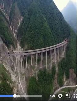
انغمر جزء من طريق قرة قرم بسبب هذا الانهيار الأرضي. وفي 14 سبتمبر 2015، قام رئيس وزراء پاكستان[12] بإفتتاح تعديل جزء طوله 24 كيلومتر من الطريق ليضم خمس أنفاق في بحيرة عطا آباد. الأنفاق الخمس البالغ طولها سبعة كيلومترات هي جزء من الجزء المعدل البالغ 24 كم من طريق قرة قرم (KKH) الذي تضرر في عام 2010 بسبب الانهيار الأرضي في عطا آباد. The realignment project is a construction master piece completed at the cost of $275 million. The realignment restored the road link between Pakistan and China and it is expected that significant amount of trade will be conducted between China and Pakistan through KKH. KKH is also a part of Pakistan China Economic Corridor, and is expected to significantly increase economic integration between China and Pakistan. The construction of state of art highways in this region China and Pakistan are currently pursuing significant number of infrastructure, communication and energy projects throughout the country. In addition, the tourists from all over the country and abroad and flocking to Northern Pakistan to see this construction master piece. Pakistan is on fast track to economic, social and infrastructure development phase. الأنفاق هي جزء من الرواق الاقتصادي الپاكستاني الصيني.
البعد العرقي لكارثة البحيرة
وادي گوجال، الذي ناله أكبر الضرر من تشكل تلك البحيرة، هو موطن ثلاث جماعات عرقية نادرة، وهم واخي (80%), بوروشاسكي (18%)، و دوماكي (2%).[13] The entire population of Domaki speakers, a very small minority and historically marginalized community, was displaced from their village of Shishkat.
الواخي وبوروشاسكي الذين يتكلمون لغات نادرة تأثروا بشدة من الكارثة.
انظر أيضاً
- نفق عطا آباد
- Tangjiashan Lake, also formed by a landslide
- بحيرة سارز، بحيرة كبيرة تكونت بسبب انهيار أرضي
- Red Lake (Romania), a mountain lake formed by a landslide
- Cyclone Phet
- 2010 Gansu mudslide
- 2010 Salang avalanches
- 2010 Leh floods
- فيضانات پاكستان 2010
الهامش
- ^ http://pamirtimes.net/tag/gojal-lake-hazard/
- ^ أ ب ت ث Shabbir Ahmed Mir (26 May 2010). "Attabad lake swallows Shishkat". The Express Tribune. Archived from the original on 27 May 2010. Retrieved 24 May 2010.
{{cite web}}: Unknown parameter|deadurl=ignored (|url-status=suggested) (help) - ^ خطأ استشهاد: وسم
<ref>غير صحيح؛ لا نص تم توفيره للمراجع المسماةTNI2 - ^ http://pamirtimes.net/tag/gojal-lake/
- ^ Siddiqi, Tanvir (24 May 2010). "Attabad Lake submerges more homes". PakObserver. Retrieved 24 May 2010.
- ^ "Attabad Lake victims end protest after talks". The Nation. 22 May 2010. Retrieved 24 May 2010.
- ^ Water level rising in Attabad lake
- ^ Michael Bopp; Judie Bopp (May 2013). "Needed: a second green revolution in Hunza" (PDF). HiMaT. p. 4. Retrieved 26 November 2015. Karakorum Area Development Organization (KADO), Aliabad
- ^ Dave Petley (4 June 2010), Attabad spillway flow update of 08:30 this morning, Durham University, England, http://hunzalandslide.blogspot.com/2010/06/attabad-spillway-flow-update-of-0830.html, retrieved on 26 November 2015
- ^ "Water level rising continuously in Attabad Lake". Dawn. 18 June 2010. Retrieved 26 November 2015.
- ^ "Attabad lake affectees end protest after Govt assurance of compensation". Online International News Network. 22 May 2010. Retrieved 24 May 2010.
- ^ "PM Nawaz to inaugurate Attabad Karakoram Highway Realignment Project on Monday | The News Teller". www.thenewsteller.com. Retrieved 2015-10-01.
- ^ http://simurgh-simurgh.blogspot.com/2010/12/tragedy-of-dispossessed.html
وصلات خارجية
- Hunza Landslide Relief Support, daily updated information with downloadable GIS data for non-profit use | LOCAL.com.pk
- Complete news coverages and photographs | Pamir Times
- Monitoring blog by Professor Dave Petley, Durham University, England
- Ata Abad Lake on Google Maps, Input Requested from Contributors | ProPakistani
- Google LatLong: Map Makers respond to the Pakistan landslides
- Landslide Lake on Hunza River Overflows into Spillway - Earth Observatory (NASA)
- [1] Thread on Hunza Gojal Lake
- [2] Pakistan
- [3] Landslide lake in Pakistan, Boston.com big pictures
- File:Documentary on Attabad Lake Hunza

