ملف:Ph locator nir.svg

حجم معاينة PNG لذلك الملف ذي الامتداد SVG: 412 × 599 بكسل. البعد الآخر: 1٬409 × 2٬048 بكسل.
الملف الأصلي (ملف SVG، أبعاده 4٬200 × 6٬105 بكسل، حجم الملف: 1٫49 ميجابايت)
وصف قصير
| ⧼wm-license-information-description⧽ |
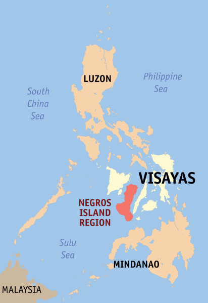
English: Map of the Philippines showing the location of the now defunct Negros Island Region.
|
| ⧼wm-license-information-date⧽ | 2019 |
| ⧼wm-license-information-source⧽ | Own work, based on seav's locator maps and Felipe Aira's File:PhlMapCit.svg |
| ⧼wm-license-information-author⧽ | HueMan1 |
ترخيص
تاريخ الملف
اضغط على زمن/تاريخ لرؤية الملف كما بدا في هذا الزمن.
| زمن/تاريخ | صورة مصغرة | الأبعاد | مستخدم | تعليق | |
|---|---|---|---|---|---|
| حالي | ★ مراجعة معتمدة 22:06، 4 أكتوبر 2023 | | 4٬200 × 6٬105 (1٫49 ميجابايت) | Pastakhov (نقاش | مساهمات) | Upload https://upload.wikimedia.org/wikipedia/commons/c/c8/Ph_locator_nir.svg |
لا يمكنك استبدال هذا الملف.
وصلات
لا يوجد صفحات تصل لهذه الصورة.