ملف:COVID-19 Cases in Connecticut by counties.png

حجم هذه المعاينة: 800 × 583 بكسل. البعد الآخر: 1٬624 × 1٬184 بكسل.
الملف الأصلي (1٬624 × 1٬184 بكسل حجم الملف: 116 كيلوبايت، نوع MIME: image/png)
وصف قصير
| ⧼wm-license-information-description⧽ |
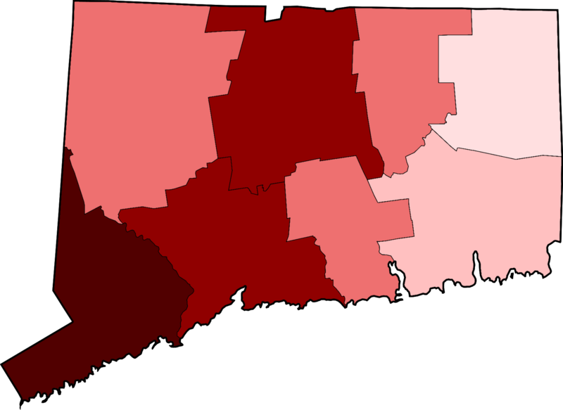
English: Map of the COVID-19 outbreak as of 25 March 2020 in the state of Connecticut in the United States. Cases here are sourced from the website of the Connecticut state government.
> 250 confirmed cases
100-249 confirmed cases
50-99 confirmed cases
15-49 confirmed cases
5-14 confirmed cases
1-4 confirmed cases
0 confirmed cases
The base maps used for this map are [File:Map of Connecticut highlighting Hartford County.svg] and [Map of Connecticut highlighting Fairfield County.svg] |
| ⧼wm-license-information-date⧽ | 2020 |
| ⧼wm-license-information-source⧽ | ⧼Wm-license-own-work⧽ |
| ⧼wm-license-information-author⧽ | Khu'hamgaba Kitap |
ترخيص
|
تاريخ الملف
اضغط على زمن/تاريخ لرؤية الملف كما بدا في هذا الزمن.
| زمن/تاريخ | صورة مصغرة | الأبعاد | مستخدم | تعليق | |
|---|---|---|---|---|---|
| حالي | ★ مراجعة معتمدة 01:25، 2 نوفمبر 2023 | | 1٬624 × 1٬184 (116 كيلوبايت) | Pastakhov (نقاش | مساهمات) | Upload https://upload.wikimedia.org/wikipedia/commons/b/be/COVID-19_Cases_in_Connecticut_by_counties.png |
لا يمكنك استبدال هذا الملف.
وصلات
لا يوجد صفحات تصل لهذه الصورة.