ملف:Bull run river oregon watershed map.png
لا توجد دقة أعلى متوفرة.
Bull_run_river_oregon_watershed_map.png (710 × 420 بكسل حجم الملف: 64 كيلوبايت، نوع MIME: image/png)
وصف قصير
| ⧼wm-license-information-description⧽ |
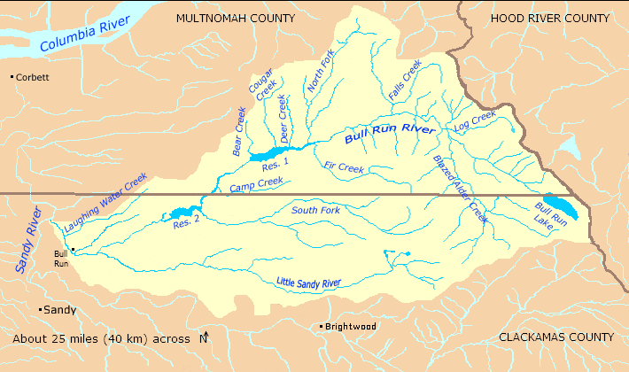
English: Map of the Bull Run River watershed — in Multnomah and Clackamas counties of northern Oregon, Western United States.
|
| ⧼wm-license-information-date⧽ | 2010 |
| ⧼wm-license-information-source⧽ | Taken from U.S. Census website here and modified by User:Finetooth. Watershed boundaries from the Sandy River Basin Partners here. City and community locations from Oregon Atlas and Gazetteer (2008), DeLorme Mapping, pp. 29–30, ISBN 0-89933-347-8. |
| ⧼wm-license-information-author⧽ | U.S. Census, Finetooth |
| ⧼wm-license-information-permission⧽ (⧼wm-license-information-permission-reusing-text⧽) |
U.S. government work in public domain; my modifications licensed under GFDL, CC-BY-SA-3.0 |
ترخيص
|

تاريخ الملف
اضغط على زمن/تاريخ لرؤية الملف كما بدا في هذا الزمن.
| زمن/تاريخ | صورة مصغرة | الأبعاد | مستخدم | تعليق | |
|---|---|---|---|---|---|
| حالي | ★ مراجعة معتمدة 09:21، 2 ديسمبر 2023 | | 710 × 420 (64 كيلوبايت) | Pastakhov (نقاش | مساهمات) | Upload https://upload.wikimedia.org/wikipedia/commons/1/10/Bull_run_river_oregon_watershed_map.png |
لا يمكنك استبدال هذا الملف.
وصلات
لا يوجد صفحات تصل لهذه الصورة.