ملف:Battle of Chelsea Creek.jpg
لا توجد دقة أعلى متوفرة.
Battle_of_Chelsea_Creek.jpg (661 × 401 بكسل حجم الملف: 183 كيلوبايت، نوع MIME: image/jpeg)
وصف قصير
| ⧼wm-license-information-description⧽ |
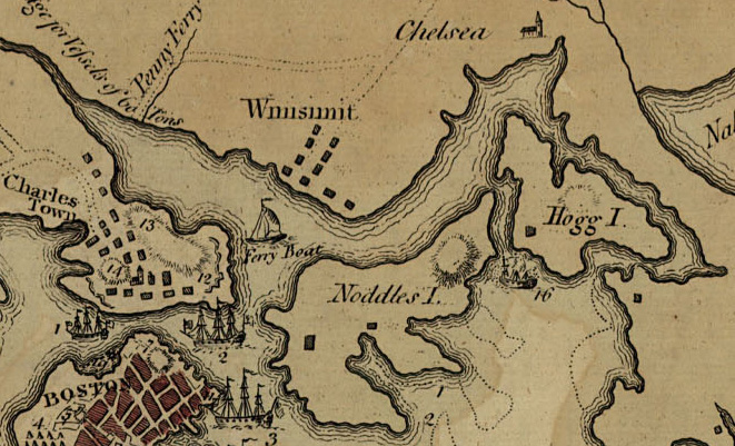
English: Detail from File:Lexington Concord Siege of Boston.jpg
"A plan of the town and harbour of Boston and the country adjacent with the road from Boston to Concord, shewing the place of the late engagement between the King's troops & the provincials, together with the several encampments of both armies in & about Boston. Taken from an actual survey. Humbly inscribed to Richd. Whitworth by J. De Costa; C. Hall, sc." hand colored map 37 X 49 cm. Created: July 29 1775, London |
| ⧼wm-license-information-date⧽ | 1775 |
| ⧼wm-license-information-source⧽ | Library of Congress Geography and Map Division Washington, D.C. 20540-4650 USA
G3764.B6S3 1775 .D4 Vault g3764b ar090000 http://hdl.loc.gov/loc.gmd/g3764b.ar090000 "The Library of Congress is providing access to these materials for educational and research purposes and is not aware of any U.S. copyright protection (see Title 17 of the United States Code) or any other restrictions in the Map Collection materials." |
| ⧼wm-license-information-author⧽ | J. DeCosta |
قالب:Works created more than 200 years ago
ترخيص
|
|
This file is in the ملكية عامة because its copyright has expired in the United States and those countries with a copyright term of no more than the life of the author plus 100 years.
|
قالب:Original upload log
| زمن/تاريخ | الأبعاد | مستخدم | تعليق |
|---|---|---|---|
| 2007-08-13 05:12 | 661×401× (187601 bytes) | Flying Jazz | Detail from [[Image:Lexington Concord Siege of Boston.jpg|thumb]] "A plan of the town and harbour of Boston and the country adjacent with the road from Boston to Concord, shewing the place of the late engagement between the King's troops & the provincial |
تاريخ الملف
اضغط على زمن/تاريخ لرؤية الملف كما بدا في هذا الزمن.
| زمن/تاريخ | صورة مصغرة | الأبعاد | مستخدم | تعليق | |
|---|---|---|---|---|---|
| حالي | ★ مراجعة معتمدة 10:03، 13 أكتوبر 2023 | | 661 × 401 (183 كيلوبايت) | Pastakhov (نقاش | مساهمات) | Upload https://upload.wikimedia.org/wikipedia/commons/e/e0/Battle_of_Chelsea_Creek.jpg |
لا يمكنك استبدال هذا الملف.
وصلات
لا يوجد صفحات تصل لهذه الصورة.