ملف:Map of Amami Gunto National Park.svg

حجم معاينة PNG لذلك الملف ذي الامتداد SVG: 800 × 600 بكسل. البعد الآخر: 2٬560 × 1٬920 بكسل.
الملف الأصلي (ملف SVG، أبعاده 1٬000 × 750 بكسل، حجم الملف: 608 كيلوبايت)
وصف قصير
| ⧼wm-license-information-description⧽ |
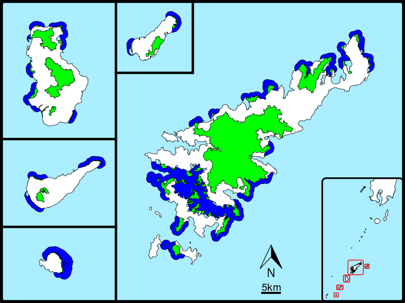
English: Area map of the Amami Gunto National Park
Land area
Ocean area (Japanese) |
| ⧼wm-license-information-date⧽ | 2017 |
| ⧼wm-license-information-source⧽ | Using the orientation symbol File:North Pointer.svg(PD)
English: Scheme of Amami Gunto National Park - the Ministry of the Environment, the Government of Japan
(Japanese) |
| ⧼wm-license-information-author⧽ | ⧼Wm-license-own-work⧽ |
|
|
This image was created with Inkscape. |
ترخيص
|
تاريخ الملف
اضغط على زمن/تاريخ لرؤية الملف كما بدا في هذا الزمن.
| زمن/تاريخ | صورة مصغرة | الأبعاد | مستخدم | تعليق | |
|---|---|---|---|---|---|
| حالي | ★ مراجعة معتمدة 21:06، 1 نوفمبر 2023 | | 1٬000 × 750 (608 كيلوبايت) | Pastakhov (نقاش | مساهمات) | Upload https://upload.wikimedia.org/wikipedia/commons/e/e2/Map_of_Amami_Gunto_National_Park.svg |
لا يمكنك استبدال هذا الملف.
وصلات
لا يوجد صفحات تصل لهذه الصورة.